

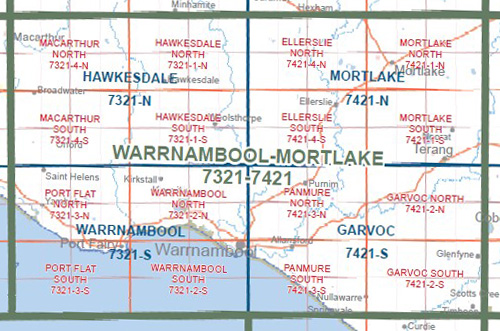
WARRNAMBOOL MORTLAKE 1-100,000 Vicmap 7321-7421
$14.00
Description:
WARRNAMBOOL MORTLAKE 1-100,000 Vicmap 7321-7421 NOW PRINT ON DEMAND is used for Walking, 4WD, Fishing, Camping, Motorcycle, both On and Off Road, Gold Prospecting and for those simply going for a family weekend drive.
This is a new series of 1-100,000 scale maps, all of Victoria is covered by these maps.
Topographical maps show not only Contours of the Terrain but Walking Tracks, Sealed and Unsealed Roads, Rivers, Creeks, Lakes, Historical Points of Interest, Old Mine Sites and National and State Park areas.
Main Features of this map includes:
Warrnambool, Mortlake, Garvoc, Macarthur, Ripponhurst, Minjah, Hexham, Noorat, Glenormiston North, Ellerslie, Woolsthorpe, Willatook, Orford, St Helens, Warrong, Framlingham, Terang, MOUNT WARRNAMBOOL, Grassmere
Junction, Woodford, Koroit, Yambuk, Mount Hotspur, Rosebrook, Dennington, Allansford, Glenfyne, Naringal, Port Fairy, LADY JULIA PERCY ISLAND, Timboon, Nullawarra
You may also like…
-
Hawkesdale 1-50,000 Vicmap
Price range: $12.00 through $24.00Select options This product has multiple variants. The options may be chosen on the product page -
Garvoc 1-50,000 Vicmap
Price range: $12.00 through $24.00Select options This product has multiple variants. The options may be chosen on the product page -
Mortlake 1-50,000 Vicmap
Price range: $12.00 through $24.00Select options This product has multiple variants. The options may be chosen on the product page -
Corangamite 1-50,000 Vicmap
Price range: $12.00 through $24.00Select options This product has multiple variants. The options may be chosen on the product page