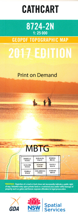
Cathcart 1-25,000 NSW Topographic Map
Price range: $16.95 through $28.95
Description:
Cathcart 1-25,000 NSW Topographic Map 8724-2-N Print on Demand
Cathcart 1-25,000 Scale NSW Topographical Map is used for Walking, 4WD, Fishing, Camping, Motorcycle, both On and Off Road, Gold Prospecting and for those simply going for a family weekend drive.
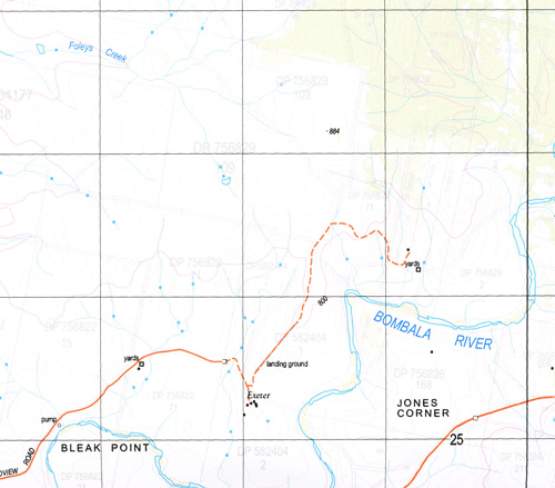
Topographicalmaps show not only Contours of the Terrain but also Walking Tracks, Sealed andUnsealed Roads, Rivers, Creeks, Lakes, Historical Point of Interest, Old MineSites and National and State Park areas.
This map includes the following localities: Archys Flat Badgerys Creek Badgerys Swamp Bald Hills Bibbenluke Bibbenluke Public School Black Lake Black Springs Cathcart Cathcart Public School Cathcart State Forest Coolumbooka River Mount Faunce Gerathys Creek Green Lake Hains Swamp Catchcart Garathys Creek Horseys Swamp Lighthouse Hill Little River Mount Marshall Moores Spring Creek Pickering Pickerings Creek Pickerings Pick Creek Pipeclay Creek Pipe Clay Swamp Pipeclay Swamp Creek Poddy Hut Shearers Hut Creek Shoemakers Creek Stockade Creek Sugarloaf Tantawangalo State Forest Tantawanglo State Forest Teatree Creek Tea Tree Creek Yellow Waterhole Yellow Water Hole Dragon Swamp Creek Dragon Swamp Burnima Bleak Point Campbells Hill The Coal Hole Foleys Creek Jones Corner Racecourse Lake Mount Bibbenluke Staffords Creek Horseys Swamp Creek Jim Rutherford Sportsground
| Scale: | 1:25000 |
| Latitude Range: | 36 45.0 S – 36 52.5 S |
| Longitude Range: | 149 15.0 E – 149 30.0 E |
| Approx Print Size: | 0.56m X 1.11m |
| Projection: | Transverse Mercator |
You may also like…
-
Bega 1-250,000 Topographic Map GA
Price range: $15.95 through $27.95Select options This product has multiple variants. The options may be chosen on the product page -
Candelo 1-25,000 NSW Topographic Map 8824-3-N
Price range: $16.95 through $29.95Select options This product has multiple variants. The options may be chosen on the product page -
Bega 1-25,000 NSW Topographic Map 8824-1-S
Price range: $16.95 through $29.95Select options This product has multiple variants. The options may be chosen on the product page