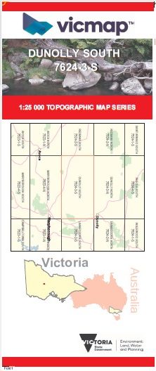

DUNOLLY SOUTH 1-25,000 Vicmap Topo Map 7624-3-S
Price range: $14.00 through $26.00
Description:
DUNOLLY SOUTH 1-25,000 Vicmap Topographic Map 76243S Now Print On Demand is used for Walking, 4WD, Fishing, Camping, Motorcycle, both On and Off Road, Gold Prospecting and for those simply going for a family weekend drive.
This is a new series of 1-25,000 scale maps, all of Victoria is now covered by these maps, including maps over the South Australian and NSW Borders.
Topographical maps show not only Contours of the Terrain but Walking Tracks, Sealed and Unsealed Roads, Rivers, Creeks, Lakes, Historical Points of Interest, Old Mine Sites, mbtg and National and State Park areas.
Main Features of this map includes:
Now also covers the old series 1-25,000 Vicmap Dunolly South
Archdale Junction, Bowenvale, Dunluce, Black Ranges, Wiseman Hill, Burkinshaw Swamp, Timor, Rathscar, Broom Hill, Blind Creek Bridge, Part of Mount Hooghly SF, mbtg, Goosebery Hill Tunnel HR, Spicer Hill, Broom Hill, Bradshaw Swamp, Wareek, Bet Bet Creek, Lake Cogumbul, Nuggety Gully Reservoir, Happy Tommy Creek, Parkers Bridge.
You may also like…
-
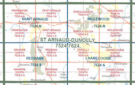
Laanecoorie 1-50,000 Vicmap Topographic Map 7624-S
Price range: $14.00 through $26.00Select options This product has multiple variants. The options may be chosen on the product page -
LAANECOORIE NORTH 1-25,000 Vicmap Topo 7624-2-N
Price range: $14.00 through $26.00Select options This product has multiple variants. The options may be chosen on the product page -
DUNOLLY NORTH 1-25,000 Vicmap Topo Map 7624-3-N
Price range: $14.00 through $26.00Select options This product has multiple variants. The options may be chosen on the product page -
LAANECOORIE SOUTH 1-25,000 Vicmap Topo 7624-2-S
Price range: $14.00 through $26.00Select options This product has multiple variants. The options may be chosen on the product page