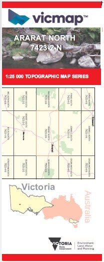
Ararat North 1-25,000 Vicmap Old Series
$11.00 – $23.00
Description:
Ararat North 1-25,000 scale Vicmap Topographical map 74232n is used for Walking, 4WD, Fishing, Camping, Motorcycle, both On and Off Road, Gold Prospecting and for those simply going for a family weekend drive.
This is a new series of 1-25,000 scale maps, only certain sections of Victoria are covered by these maps.
Topographical maps show not only Contours of the Terrain but Walking Tracks, Sealed and Unsealed Roads, Rivers, Creeks, Lakes, Historical Points of Interest, Old Mine Sites and National and State Park areas.
Main Features of this map includes:
Ararat, JALLUKAR NCR, Lexington Bridge, Moyston, LENNOX SPRINGS BR, Willaura North, Kirk Hill, Hopkins Creek, Pinkey Point Gold Discovery, ARARAT Regional Park, NAPOLEON Hill, Bridal Hill, Acacia Caravan and Tourist Park, Oliver Gully Reservoir, MOUNT CHALAMBER, SARSAPARILLA Hill, Denicull Creek, SHEEPFOLD Hill, LANGI LOGAN Disused, MONTARA BR, Pyrenees Caravan Park, Mcdonald Park Wildflower Reserve, NOAHS ARK DAM NFR, Hopkins Correctional Centre, Green Hill Lake, Ararat Racecourse And Recreation Reserve, Jacksons Creek, Gorrin Creek
Old Series Ararat North, a new edition now available, see link below