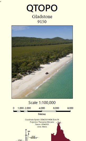
Gladstone 1-100,000 Topographic Map
Price range: $15.95 through $30.95
Description:
Locations within this Map
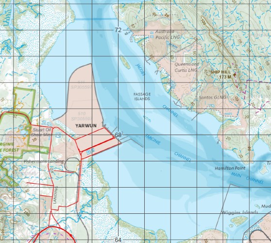
Woodcot Tidalmaree Edwards Fairview Carrara Clifton Farm Wycheproof castle Hope Mountain View Black Gate Gladstone Tannum Sands Southend Aldoga Auckland Auckland Creek Auckland Hill Auckland Inlet Auckland Point Auckland Point Reef Badger Creek Barker Creek Mount Barker Barney Point Mount Barney Bass Shoals Mount Beecher Biondello Birkenhead Black Head Black Swan Creek Black Swan Island Blackfellow Blower Spit Boat Creek Boatshed Point Boundary Creek Boyne Island Boyne River Briffney Creek Burua Bushy Island Byellee Callemondah Calligooran Creek Calliope Calliope Crossing Calliope River Camp Island Canoe Point Carthurbie Creek Casuarina Clump Cattle Creek Central Hill Centre Creek Cherry Creek Chinaman Island Clarke Creek Clinton Clinton Park Clyde Creek Coast Hill Cogoa Creek Compigne Channel Compigne Island Connor Bluff Curley Curtis Curtis Island Curtis Rock Port Curtis Cutter Creek Datum Point Deception Creek Deep Creek Devils Elbow Diamantina Island Division Point Double Creek Dry Creek Dudor Duffy Creek East Banks East Point East Point Ledge East Stowe Elizabeth Peak Endfield Creek Entrance Ledge Facing Channel Facing Island Farmer Creek Farmers Island Farmers Point Farmers Reef Fishermans Landing Freshwater Lagoon Friend Point Garden Island Gatcombe Gatcombe Channel Gatcombe Head Ginger Beer Creek Golding Graham Graham Creek Grass Point Gravel Creek Grayson Greens Creek Hamilton Point Hay Island Hetherington Hobble Gully Humpy Creek Kangaroo Island Kin Kora Creek Laird Point Larcom Creek Mount Larcom Leixlip Creek Lilly Hills Logbridge Creek Machine Creek Main Channel Major Creek Manning Reef Maria Inlet Maroon Creek Mount Martin Maurice Hill Mount McCabe McGintys Gully Middle Bank Middle Creek Mina Rock Monte Christo Monte Christo Creek Mosquito Creek Mount Miller Mud Island Munduran Creek North Bank North Channel North Entrance North Point Northcliffe Nutmeg Gully O’Connell Ridges Oaky Creek Observation Point Ogre Creek Oyster Rock Paper Tree Creek Parana Parsons Point Passage Islands Pearl Ledge Pelican Banks Permean Point Phryne Picnic Island Pink Lily Lagoon Police Creek Pyealy Pyealy Creek Quoin Channel Quoin Island Ramsay Crossing Ramsay Range Randalls Landing Rat Island Rawbelle Creek Redcliff Island Rich Rocks Ripple Rock Rock Point Rocky Glen Rocky Point Mount Rollo Roma Rock Round Hill Rundle Island Rundle Range Sable Chief Rocks Sandhill Sandy Creek Scrubby Creek Scrubby Mountain Seal Rocks Settlement Point She Oak Island Ship Hill Shoal Bay Sneaker Creek South Channel South Trees South Trees Inlet South Trees Island South Trees Point Spring Creek Station Creek Stirrat Stowe Mount Stowe Mount Sugarloaf Tail Point Targinie Targinie Creek Telegraph Creek Teningie Creek The Duck Holes The Narrows Tiber Point Tide Island Tigalee Creek Tondoon Tondoon Creek Toolooa Turtle Island View Hill Vulcan Creek Wapentake Creek Watson West Banks West Stowe White Hill White Rock Wiggins Islands Wild Cattle Beach Wild Cattle Creek Wild Cattle Island Witt Island Worthington Island Wurdong Creek Wurdong Hill Yarwun Auckland Channel South Gladstone Talaba Boyne Island Conservation Park Curtis Island National Park Garden Island Conservation Park Wild Cattle Island National Park Panorama Point Beecher East End River Ranch Wurdong Heights Calliope Conservation Park Curtis Island State Forest Gladstone Central Gladstone Harbour Glen Eden Kin Kora Kirkwood New Auckland O’Connell Sun Valley Telina West Gladstone Cape Capricorn Rocky Island Sea Hill Island Ramsay Ford Christo Creek Black Swan Islet Red Cliff Island Redcliffe Island Mud Creek Friends Point Grahams Creek Rat Islet Southend Jetty Rich Hill Southend Channel Chinaman Islet Farmer Point Mount Larcom Range South Passage Island Passage Island Fishermans Landing Wharf Targinie Channel Turtle Islet Targima Targinnie Passage Spit Ripple Reef Tide Islet Mud Islet Permian Point Permein Point Clinton Channel Middle Banks Clinton Wharves Wiggins Islet Wiggins Islets Auckland Point Wharves Rich Rock Bushy Islet Barney Point Wharf Welby Creek South Trees Anchorage South Trees Wharf Boyne Valley Junction One Tree Hill South Tree Inlet East Bank Port of Gladstone South Entrance Red Cliff Creek Elizebeth Peak Wurdong Boyne Range
| Name: | 9150 |
| Publisher: | Queensland Government |
| Scale: | 1:100000 |
| Latitude Range: | 23° 30.0′ S – 24° 00.0′ S |
| Longitude Range: | 151° 0.0′ E – 151° 30.0′ E |
| Projection / Datum: | Universal Transverse Mercator, GDA 94 |
| Approx Print Size: | 0.56m X 0.56m |