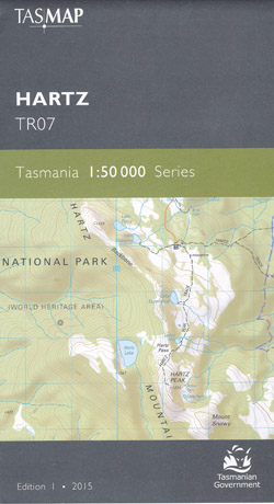
Hartz 1-50,000 Topographic Map Tasmap
$13.95
2 in stock
Description:
Hartz 1-50,000 Tasmap Topographic Map
This map covers the rural areas of Geeveston and Glen Huon and also depicts the access routes via the Picton and Huon Rivers to the wilderness areas of Tasmania’s South West. An ideal map for rafters and explorers of the wilderness.
1:50,000 Scale topographic map. 1cm = 2km. Roads, tracks, watercourses, land features, buildings etc.
Coverage includes Hartz Peak, Picton River, Huon River (parts), Geeveston, Port Huon, Surges Bay, Tahune Forest, Lower Weld River, Mount Picton, South Picton Range.
|
||||||||||||||||||
Read More
You may also like…
-
Lake Pedder 1-50,000 Topographic Map Tasmap
Price range: $13.95 through $25.95Select options This product has multiple variants. The options may be chosen on the product page -
Tasmania South East 1-250,000 Map Tasmap
Price range: $13.95 through $25.95Select options This product has multiple variants. The options may be chosen on the product page -
Tasmania South West 1-250,000 Map Tasmap
Price range: $13.95 through $25.95Select options This product has multiple variants. The options may be chosen on the product page -
Hartz Mountains National Park Map Tasmap
Price range: $12.95 through $24.95Select options This product has multiple variants. The options may be chosen on the product page -
Western Arthur 1-50,000 Topographic Map Tasmap
Price range: $13.95 through $25.95Select options This product has multiple variants. The options may be chosen on the product page