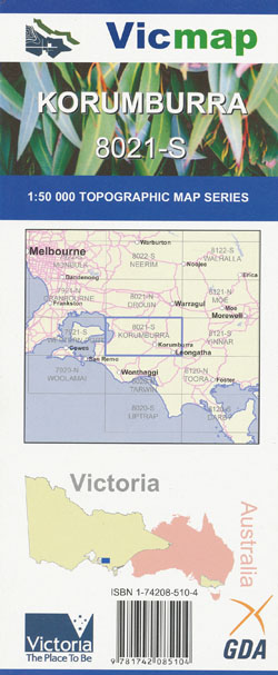


Korumburra 1-50,000 Vicmap
Price range: $14.00 through $26.00
Description:
Korrumburra 1-50,000 scale Victorian Topographical map 8021S is used for Walking, 4WD, Fishing, Camping, Motorcycle, both On and Off Road, Gold Prospecting and for those simply going for a family weekend drive.
Topographical maps show not only Contours of the Terrain but Walking Tracks, Sealed and Unsealed Roads, Rivers, Creeks, Lakes, Historical Point of Interest, Old Mine Sites mbtg and both National and State Park areas.
Main Features of this map includes:
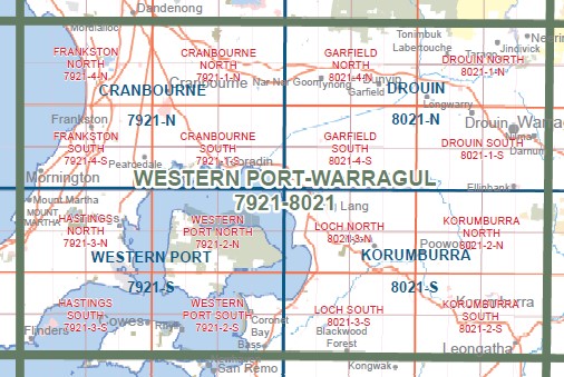
The Eastern Edge of Western Port Bay
The towns of Korrumburra, Lang Lang, Leongatha, Nyora, Poowong, Most of Mt Worth State Park, LANG LANG RIVER TOPIRAM SSR, Hallora, Strzelecki, Seabrook Park, Wild Dog Valley, Allambee Plantation, Moonlight Walking Track, Trida, Ferndale, Mount Eccles, Bawdens Creek Falls, mbtg, Courtney Creek Falls, Lorkin Creek Falls, Gardiners Mill Site, GARDINERS MILL TRACK, Trevorrows Mill Site, Seymours Mill Site, Bromfields Mill Site, mbtg, Loch, Lang Lang, Nyora, Lang Lang Foreshore Caravan Park, Lang Lang Beach, Jam Jerrup, The Gurdies, HURDY GURDY CREEK NCR, ADAMS CREEK NCR, LANG LANG EA and Camp, mbtg, MOSQUITO Hill, NYORA WONTHAGGI Rail disused
Grantville, Jeetho, WESTERN PORT FORESHORE RESERVE GRANTVILLE COAST RESERVE, Queensferry, GRANTVILLE NCR, Bass River, Woolamai (not on Phillip Island), Glen Forbes, Candowie Reservoir, Almurta, The Gurdies, The Gurdies Winery, St Helier, KERNOT Disused, Almurta East, Glen Alvie, Telfer Creek, mbtg, Woodleigh, NYORA WONTHAGGI rail disused, Krowera, Lance Creek Reservoir, Moyarra, mbtg, Loch, Lang Lang, Nyora, Lang Lang Foreshore Caravan Park, Lang Lang Beach, Jam Jerrup, The Gurdies, HURDY GURDY CREEK NCR, ADAMS CREEK NCR, LANG LANG EA and Camp, mbtg, MOSQUITO Hill
ISBN 9781742085104
You may also like…
-
KORUMBURRA SOUTH 1-25,000 Vicmap Topo 8021-2-S
Price range: $14.00 through $26.00Select options This product has multiple variants. The options may be chosen on the product page -
Tarwin 1-50,000 Vicmap Topographical Map 8020-N
Price range: $14.00 through $26.00Select options This product has multiple variants. The options may be chosen on the product page -
Drouin 1-50,000 Vicmap
Price range: $12.00 through $24.00Select options This product has multiple variants. The options may be chosen on the product page -
KORUMBURRA NORTH 1-25,000 Vicmap Topo 8021-2-N
Price range: $14.00 through $26.00Select options This product has multiple variants. The options may be chosen on the product page -
LOCH SOUTH 1-25,000 Vicmap Topo Map 8021-3-S
Price range: $14.00 through $26.00Select options This product has multiple variants. The options may be chosen on the product page -
South Gippsland Wilsons Promontory Map Rooftop
Price range: $11.95 through $25.00Select options This product has multiple variants. The options may be chosen on the product page -
Yinnar 1-50,000 Vicmap
Price range: $12.00 through $24.00Select options This product has multiple variants. The options may be chosen on the product page -
Korumburra 1-50,000 Vicmap
Price range: $14.00 through $26.00Select options This product has multiple variants. The options may be chosen on the product page -
Western Port 1-50,000 Vicmap
Price range: $14.00 through $26.00Select options This product has multiple variants. The options may be chosen on the product page -
LOCH NORTH 1-25,000 Vicmap Topo Map 8021-3-N
Price range: $14.00 through $26.00Select options This product has multiple variants. The options may be chosen on the product page