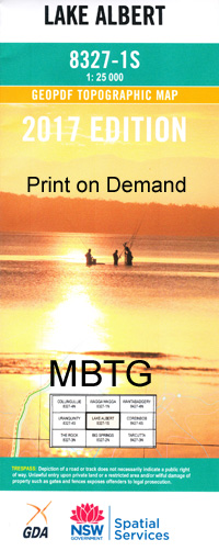
Lake Albert 1-25,000 NSW Topographic Map
$16.95
Description:
8327-1-S
Lake Albert 1-25,000 scale NSW Topographical map is used for Walking, 4WD, Fishing, Camping, Motorcycle, both On and Off Road, Gold Prospecting and for those simply going for a family weekend drive.
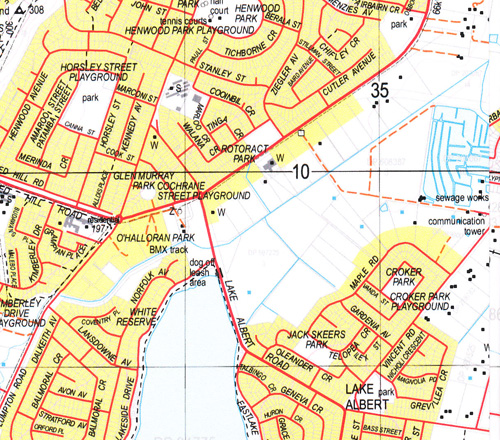
Topographical maps show not only Contours of the Terrain but also Walking Tracks, Sealed and Unsealed Roads, Rivers, Creeks, Lakes, Historical Point of Interest, Old Mine Sites and National and State Park areas.
 We can Now LAMINATE and fold your map for $12.00. Just click on the image and add to the Trolley
Locations within this Map
Forest Hill Gumly Gumly Wagga Wagga Kapooka Ashmont Public School Lake Albert Boiling Down Creek Bosley Memorial Playground Colloboralli Creek Coxs Creek Croker Park Crooked Creek Foleys Gully Forest Hill Public School Forest Hill Railway Station Gissing Oval Gregado Gregadoo Creek Gregadoo Hill Gregadoo Gumly Harris Park Henwood Park Jubilee Park Kapooka Military Camp Public School Kapooka Railway Station Kessler Park Connorton Publidc School Coxs Gully Fred White Reserve Glenrouth Gregadoo Public School Kapooka Loop Kiambeth Kiambeth Range Kiambeth Ridge Kooringal Kooringal High School Kooringal Public School Kurrajong Park Public School Kurrajong Public School Lake Albert Public School Mount Austin Mount Austin High School Mount Austin Public School O’Halloran Park Plum Pudding Plum Pudding Creek Plum Pudding Hill Pomingalarna Pomingalarna Gap Rawlings Park Riverina Youth Centre Rocky Hill Rowan Sandy Creek San Isadore San Isidore San Isidore Public School Sawpit Gully Six Mile Creek South Wagga Wagga Stringybark Creek Stringy Bark Creek Stringy Bark Creek/ Six Mile or Stringy Bark Creek Sturt Public School Tatton Tatton Public School Tea-Tree Creek Tolland Tolland Public School Turvey Park Turvey Park Public School Tywong Creek Uranquintry Village of Uranquintry Uranquinty Uranquinty Cemetery Uranquinty Public School Uranquinty Railway Station Village of Lake Albert Wagga Wagga Aerodrome Wagga Wagga General Cemtery Wagga Wagga High School Wagga Wagga Lawn Cemetery Wagga Wagga Railway Station Wagga Wagga Showground Wagga Wagga Technical College Wagga Wagga War Cemetery War Cemetery White Reserve Willans Hill Willans Hill Park Anderson Park Bourkelands French Fields Glenfield Park Lloyd Maher Oval Maher Park Wineglass Coloboralli Creek Wagga Wagga Airport Chambers Park Emblen Park Kilpatrick Park Lake Village Park Jack Skeers Park Gelston Park Springvale East Wagga Wagga Sherwood Park Ray Beddoe Park Kunming Grove Ron Wheeler Park OHalloran Park Tywong Gully Tea Tree Creek Allonby Yaruga Connorton Arundel Gregardo OBriens Creek Spring Gully Hillview Gregadoo Station
| Scale: | 1:25000 |
| Latitude Range: | 35° 7.5′ S – 35° 15.0′ S |
| Longitude Range: | 147° 15.0′ E – 147° 30.0′ E |
| Datum: | GDA 94 |
| Approx Print Size: | 0.56m X 1.11m |
| Publication Date: | 2013 |