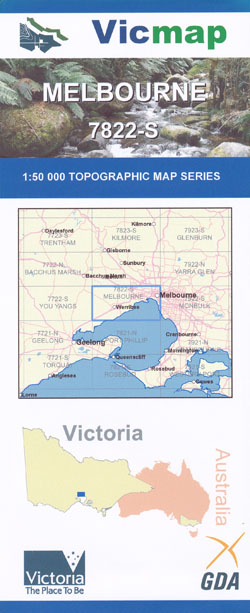
Melbourne 1-50,000 Vicmap Topographic Map
Price range: $12.00 through $24.00
Description:
Melbourne 1-50,000 scale Victorian Topographical map 7822N is used for Walking, 4WD, Fishing, Camping, Motorcycle, both On and Off Road, Gold Prospecting and for those simply going for a family weekend drive.
Topographical maps show not only Contours of the Terrain but Walking Tracks, Sealed and Unsealed Roads, Rivers, Creeks, Lakes, Historical Point of Interest, Old Mine Sites mbtg and both National and State Park areas.
Main Features of this map includes:
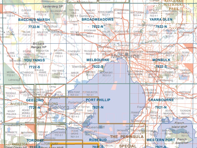
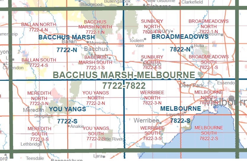
Covers the Melbourne Suburban area from Richmond, Sandringham and Northcote in the East to Little River in the West
Includes Werribee, Laverton, Melbourne City and Yarra River Mouth to Avondale Heights in the North
RAAF WILLIAMS – LAVERTON COMMONWEALTH AREA, Port Phillip Prison, William Angliss Native Grassland Reserve, Flemington Racecourse, Westgate Bridge, Point Gellibrand Historic Area, Moomee Valley Racecourse, Marvel Stadium, Yarra River, Albert Park Lake and area of F1 Raceway, Melbourne Cricket Ground MCG, Fitzroy Gardens, Captain Cooks Cottage, POINT COOK COASTAL PARK, RAAF WILLIAMS – POINT COOK COMMONWEALTH AREA,
Covers the suburbs, Melbourne City CBD, Deer Park,Burnside, Derrimut, Laverton, Cairnlea, Sunshine, Brooklyn, Altona Gate, Altona, Seaholme, Williamstown, Newport, Tottenham, Kingsville, Braybrook, Maidstone, Avendale Heights, Esendon, Maribyrnong, Aberfeldie, Moonee Ponds, Ascot Vale, Fishermans Bend, Point Gellibrand, Yarraville, Footscray, Seddon, Flemington, Travancore, Kensington, North Melbourne, West Melbourne, Docklands, Port Melbourne, Albert Park, Middle Park, South Melbourne, Southbank, South Wharf, Parkville, Princes Hill, Carlton, Brunswick, Fitzroy, Collingwood, East Melbourne, Jolimont, Richmond, Cremorne, South Yarra, Prahran, Windsor, St Kilda, Ripponlea, Abbottsford, Clifton Hill, edge of Northcote and Thornbury, Wiiliams Landing Seabrook, Altona Meadows, Point Cook, Sanctuary Lakes, Brighton, edge of Sandringham,
Eynesbury, Truganina, Manor Lake, Werribee River, WESTERN GRASSLANDS NCR, Quandong, Lollypop Creek, Mount Cottrell, Cobbledicks Streamside Reserve, Chartwell, Fieldstone, MOUNT ATKINSON, Hopper Crossing, Caroline Springs, Ravenhall Correctional Centre, Metropolitan Remand Centre, Port Phillip Prison, Laverton West, mbtg, Werribee, RAAF WILLIAMS – POINT COOK COMMONWEALTH AREA, POINT COOK COASTAL PARK, LITTLE RIVER WR, Rothwell
ISBN 9781742085302
You may also like…
-
Port Phillip 1-250,000 Topographic Map
Price range: $15.95 through $30.95Select options This product has multiple variants. The options may be chosen on the product page -
Yarra Glen 1-50,000 Vicmap
Price range: $12.00 through $24.00Select options This product has multiple variants. The options may be chosen on the product page -
Monbulk 1-50,000 Vicmap
Price range: $12.00 through $24.00Select options This product has multiple variants. The options may be chosen on the product page -
You Yangs 1-50,000 Vicmap Topographic Map
Price range: $12.00 through $24.00Select options This product has multiple variants. The options may be chosen on the product page -
Bacchus Marsh Melbourne 1-100,000 Vicmap Topo Map
Price range: $12.00 through $24.00Select options This product has multiple variants. The options may be chosen on the product page -
WERRIBEE SOUTH 1-25,000 Vicmap Topo Map 7822-3-S
Price range: $14.00 through $26.00Select options This product has multiple variants. The options may be chosen on the product page -
Melbourne North 1-25,000 Vicmap Topographic Map
Price range: $12.00 through $24.00Select options This product has multiple variants. The options may be chosen on the product page -
Bacchus Marsh 1-50,000 Vicmap
Price range: $12.00 through $24.00Select options This product has multiple variants. The options may be chosen on the product page -
Cranbourne 1-50,000 Vicmap
Price range: $12.00 through $24.00Select options This product has multiple variants. The options may be chosen on the product page -
Melbourne 1-50,000 Vicmap Topographic Map
Price range: $12.00 through $24.00Select options This product has multiple variants. The options may be chosen on the product page -
WERRIBEE NORTH 1-25,000 Vicmap Topo Map 7822-3-N
Price range: $14.00 through $26.00Select options This product has multiple variants. The options may be chosen on the product page -
Melbourne South 1-25,000 Vicmap Topographic Map
Price range: $12.00 through $24.00Select options This product has multiple variants. The options may be chosen on the product page