
Mount Anne Southwest National Park Map Tasmap
$8.95
1 in stock
Description:
Mount Anne Southwest National Park Map Tasmap
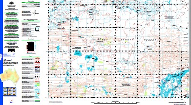
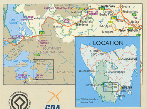
Mount Anne is located in Southwest National Park within the Tasmanian Wilderness World Heritage Area. With an elevation of 1423m, Mount Anne is the highest peak in south west Tasmania and dominates the region around Lake Pedder. Mount Anne is a difficult walk but, for most, the views and experience are worth the effort.
The cover photo is by Becca Lunnon, winner of the “Your photo on your TASMAP” competition. Becca’s photo, Mount Anne from Lots Wife, was taken on what she described as a slightly ambitious solo day trip into Lots Wife, hampered by a recent snowfall.
ISBN: 9318923029536
| Edition: | 1 |
| Production Year: | 2024 |
| Datum: | GDA 2020 |
| Scale: | 1:1:40000 |
|
|
|
Read More
You may also like…
-
Walls of Jerusalem National Park Map Tasmap
Price range: $14.95 through $26.95Select options This product has multiple variants. The options may be chosen on the product page -
Bruny Island Walks Map Tasmap
Price range: $13.95 through $25.95Select options This product has multiple variants. The options may be chosen on the product page -
Frenchmans Cap Walk Map Tasmap
Price range: $8.95 through $18.95Select options This product has multiple variants. The options may be chosen on the product page -
Hartz Mountains National Park Map Tasmap
Price range: $12.95 through $24.95Select options This product has multiple variants. The options may be chosen on the product page -
Lake St Clair Day Walks Map Tasmap
Price range: $8.95 through $18.95Select options This product has multiple variants. The options may be chosen on the product page -
Highland Lakes Map and Angling Notes Tasmap
Price range: $13.95 through $24.95Select options This product has multiple variants. The options may be chosen on the product page