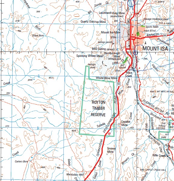
Mount Isa 1-250,000 Topographic Map
Price range: $15.95 through $30.95
Description:
Print on Demand
Part of the Diamantina Developmental Road
New May Downs Nowranie Calton Hills Mount Isa Arcadia Bore Grassy Bore No 3 Blue Bush Bore Arcadia Arcadia Water Facility Arcas Austral Downs Gate Barkly Downs Barkly Tableland Beetle Creek Benth Betterley Big Sandy Creek Blacks Lagoon Blue Bush Bluebush Water Facility Boonal Brahe Breakaway Creek Bright Brumby Waterhole Buckley Buckley River Buckley Water Faciliyy Bullecourt Burnley Bustard Creek Carleton Creek Cattle Creek Chad Crater of Caves Crooked Creek Crosthwaite Deardean Don Don Creek Donickmore Eight Mile Creek Engine Creek Flora Waterhole Forty Eight Mile Water Facility Georgina Gilchrist Grassy Water Facility Grenoble Gum Creek Hebden Holmfirth Horse Creek Inca Inca Creek Johnson Creek Jopp Waterhole Kennedy Creek Kennedy Gap Kepler King Creek King Gully Kitty Plain Kochia Lagoon Creek Leadmore Leander Range Lena Creek Letterbox Creek Lily Creek Lily Hole Creek Lima Little Sandy Creek Little Templeton River Little Toby Creek Little Wooroona Creek May Downs Meltham Mica Creek Mount Michael Miles Gully Millican Creek Mine Creek Mingera Creek Mistake Creek Mitholm Mosquito Creek Mungoona Waterhole Myrtle Nagago Nash Norden Nottingham Creek Nowranie Creek Ogilvie Range Old Wooroona Oldman Crossing Owl Creek Paroo Waterhole Pilpah Range Prestbury Prestwich Recedam Redbank Creek Rishworth Rochedale Rotary Hill Royds Royton Saint Smith Range Seven Mile Waterhole Seventy Nine Mile Water Facitity Sheepyard Waterhole Sherdon Sherrin Creek Six Mile Creek Sixteen Mile Creek Slaughteryard Creek Snake Creek Sowerby Spear North Branch Creek Spinifex Waterhole Spring Creek Star Gully Sugarbag Creek Sybella Creek Tetley The Valley Waterhole Toussaint Turkey Waterhole Twenty Nine Mile Water Facility Tycho Underilla Creek Valley Water Facility Waggaboonyah Range Walo Whistler Creek Whitegate Wilfred Creek Wonomo Wooroona Wooroona Creek Yanyeea Yaringa Creek Yelvertoft Yetman Youghal Youngrove Cammoweal Caves National Park Barkly Happy Valley Kalkadoon Lanskey Menzies Miles End Mornington Mount Isa City Parkside Ryan Soldiers Hill Spreadborough The Gap Mount Isa City Winston Dingo Creek Pear Tree Waterhole Six Mile Bore Whistler Creek Bore Whistlers Creek Bore Plain Creek Dip Waterhole Top Bullock Paddock Bore Don Creek Bore Gundiria Bore Naggaboonyah Range Flora Downs Bore Owens Bore Johnsons Lagoon Wightman Hole Wooroona Bore Beauchamps Bore Angle Waterhole Crooked Hole Buckleys Creek Bore Twenty Nine Mile Bore Galah Holes Carls Bore Old May Downs Matchbox Hole Matchbox Bore Barkley Downs Wooroona Downs Grenoble Bore Redbank Bore Redbank Kingfisher Bore Spring Creek Well Hilton Substation Lily Plain Dam K Twelve Bore Crawford Dam Mossman Bore Templeton Dam Town Bore Mary Kathleen Tailings Dam Number Ten Dam Gap Bore Templeton Bore Muddy Creek Bore Junction Bore Big Toby Creek Yaringa Bore Carters Bore Number Thirty Eight Bore Buffalo Dam Blacks Bore Toby Creek Bore Muddy Creek Dingo Hole Bore
| Name: | Mount Isa |
| Publisher: | Geoscience Australia (Australian Government) |
| Scale: | 1:250000 |
| Latitude Range: | 20° 0.0′ S – 21° 0.0′ S |
| Longitude Range: | 138° 0.0′ E – 139° 30.0′ E |
| Projection / Datum: | Universal Transverse Mercator, GDA94 |
| Approx Print Size: | 0.44m X 0.67m |
| Publication Date: | 1-Jun-09 |