Skip to content
Search for
Wholesale login
0
Categories
Gift Vouchers
4WD Maps & Books
4WD Maps and Books
See all
4WD Books Australia
4WD Maps Australia
4WD Maps for the Victoria High Country
Otways Great Ocean Road 4WD Maps
Australian Maps Books & Atlases
Australian Maps Books and Atlases
See all
ACT Maps Books and Atlases
New South Wales Maps Books and Atlases
Northern Territory Maps Books and Atlases
Queensland Maps Books and Atlases
South Australia Maps Books and Atlases
Tasmania Maps Books and Atlases
Victoria Maps Books and Atlases
Western Australia Maps Books and Atlases
New Editions
Bargain Books & Maps
Caravan & Camping
Digital Maps CD DVD & Compasses
Fishing Maps & Books
Fishing Maps and Books
See all
Fishing Books
Fishing Maps
Fishing Accessories
Geological Maps
Geological Maps
See all
Victoria Geological Maps
NSW Geological Maps
Tasmania Geological Map
NSW Data Mine Sheets
Globes World Globes & Inflatable World Globes
Gluten Free Diabetes Multi Allergy Books
Gold Prospecting Maps & Books
Hema Maps & Atlases
Hema Maps and Atlases
See all
Hema Atlases
Hema Australia Maps
Hema Cities and States Maps
Hema City to City Maps
Hema Great Desert Tracks Maps and Map Packs
Hema International Maps
Hema New Zealand Maps and Atlases
Hema Regional and National Park Maps
International Maps
International Maps
See all
Africa and Middle East Maps
Asia Maps
Canada and Mexico Maps
Europe Maps
France Maps and Atlases
India and Himalaya Region Maps
Pacific Region Maps
South and Central America Maps
UK and Ireland Maps
USA Maps
Motorcycle Road & Offroad
Topographical Maps
Topographical Maps
See all
Australian 1-50,000 Topo Maps
Australian 1-50,000 Topo Maps
See all
Australia 1-50,000 Topo Maps A-D
Australia 1-50,000 Topo Maps E-J
Australia 1-50,000 Topo Maps K-P
Australia 1-50,000 Topo Maps Q-V
Australia 1-50,000 Topo Maps W-Z
Australian 1-250,000 Topo Maps
Australian 1-100,000 Topo Maps
Australian 1-1,000,000 Topo Maps
Bargain Books & Maps
Home
/
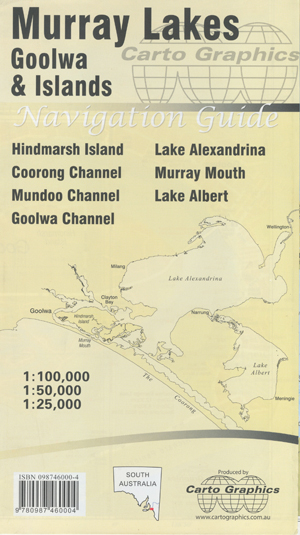
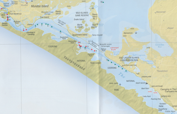
Murray Lakes Map Carto Graphics
/
Murray Lakes Map Carto Graphics
$
19.95
Out of stock
You may also like…
Limestone Coast South East SA Map Carto Graphics
$
12.95
Add to cart
Mid North Map South Australia Carto Graphics
$
12.95
Read more
Eyre Peninsula Map Carto Graphics
$
12.95
Add to cart
Murray River and Mallee Map Carto Graphics
$
12.95
Add to cart
Adelaide Hills and Barossa Map Carto Graphics
$
12.95
Add to cart
Flinders Ranges Map Carto Graphics
$
12.95
Add to cart
Fleurieu Peninsula Map Carto Graphics
$
12.95
Add to cart
South Australia Map Carto Graphics
$
12.95
Add to cart
Related products
Nullarbor Plain Map Carto Graphics
$
12.95
Read more
Melbourne to Adelaide Map RACV
$
0.00
Read more
South Australia State Folded Map Hema
$
15.95
Add to cart
South Australia Map Laminated Previously Folded
$
49.95
Add to cart
Adelaide City and Suburbs Map RACV
$
9.50
Read more
Adelaide City Streets and Suburbs Map 562 UBD
$
12.95
Read more