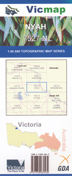
Nyah 1-50,000 Vicmap
Price range: $12.00 through $24.00
Description:
Nyah 1-50,000 scale Vicmap Topographical map 7527N is used for Walking, 4WD, Fishing, Camping, Motorcycle, both On and Off Road, Gold Prospecting and for those simply going for a family weekend drive.
Topographical maps show not only Contours of the Terrain but Walking Tracks, Sealed and Unsealed Roads, Rivers, Creeks, Lakes, Historical Points of Interest, Old Mine Sites mbtg and National and State Park areas.
Main Features of this map includes:
Murray River Nyah and Piangil towns
Piangil, Nyah-Vinifera Park – Wood Wood Camping Area, Lake Poon Boon, Piangil-Yungera Railway BR, Bucky Creek, Lake Geer, Lake Coomaroop, mbtg, part of Murray River Reserve, Murphys Island, Lake Poomah, Lake Talpile, part of Nyah-Vinifera Park, Nyah-Vinifera Park – Central Camping Area, mbtg, Nyah, Nyah West, Yarraby, Beverford, part of River Murray Reserve, Nyah-Vinifera Park, Nyah-Vinifera Park – Picks Bend Camping Area 1, Speewa Island, mbtg, Nyah-Vinifera Park – Picks Point Camping Area 3, Lake Goonimur, Lake Talpile, Lake Poomah, Lake Wollare, Nyah-Vinifera Park – Nyah South Camping Area
Piangal West, Tudor, Prooinga, Ryans BR, Bransons BR, Kookoombo West BR, mbtg, Bailey Plain Salt Pan, Turoar BR, mbtg, Turoar, Ryanby, Towan Plains FFR, Beabush Tank BR, mbtg, Towan BR, Chillingollah FFR
You may also like…
-
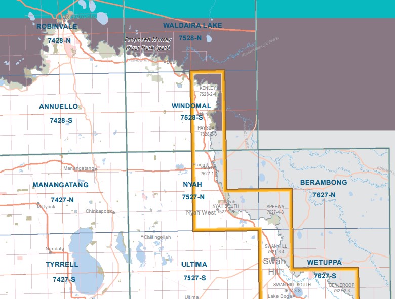
Windomal 1-50,000 Vicmap
Price range: $12.00 through $24.00Select options This product has multiple variants. The options may be chosen on the product page -
Wetuppa 1-50,000 Vicmap
Price range: $12.00 through $24.00Select options This product has multiple variants. The options may be chosen on the product page -
Ultima 1-50,000 Vicmap
Price range: $12.00 through $24.00Select options This product has multiple variants. The options may be chosen on the product page -
Berambong 1-50,000 Vicmap
Price range: $12.00 through $24.00Select options This product has multiple variants. The options may be chosen on the product page -
NYAH NORTH 1-25,000 Vicmap Topo Map 7527-1-N
Price range: $14.00 through $26.00Select options This product has multiple variants. The options may be chosen on the product page -
PIANGIL WEST SOUTH 1-25,000 Vicmap Topo 7527-4-S
Price range: $14.00 through $26.00Select options This product has multiple variants. The options may be chosen on the product page -
NYAH SOUTH 1-25,000 Vicmap Topo Map 7527-1-S
Price range: $14.00 through $26.00Select options This product has multiple variants. The options may be chosen on the product page -
PIANGIL WEST NORTH 1-25,000 Vicmap Topo 7527-4-N
Price range: $14.00 through $26.00Select options This product has multiple variants. The options may be chosen on the product page