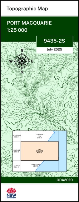
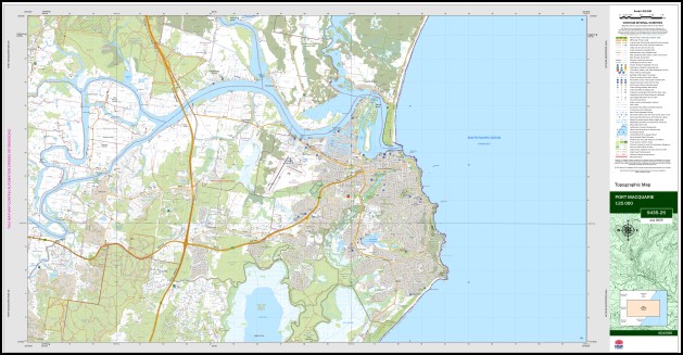
Port Macquarie 1-25,000 NSW Topo Map 9435-2-S
Price range: $16.95 through $28.95
Description:
Port Macquarie 1-25,000 NSW Topographic Map 9435-2-S Print on Demand
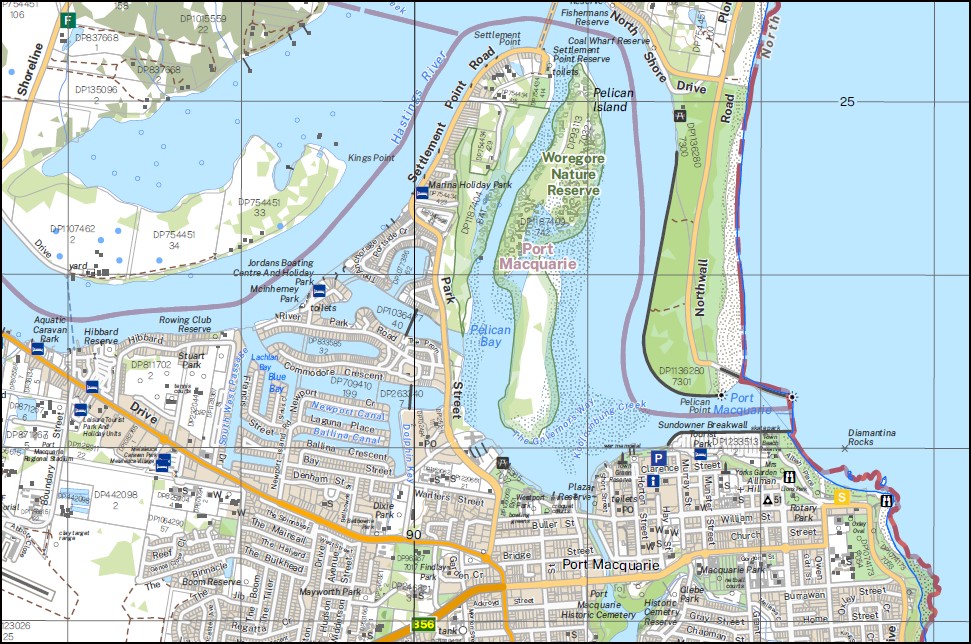
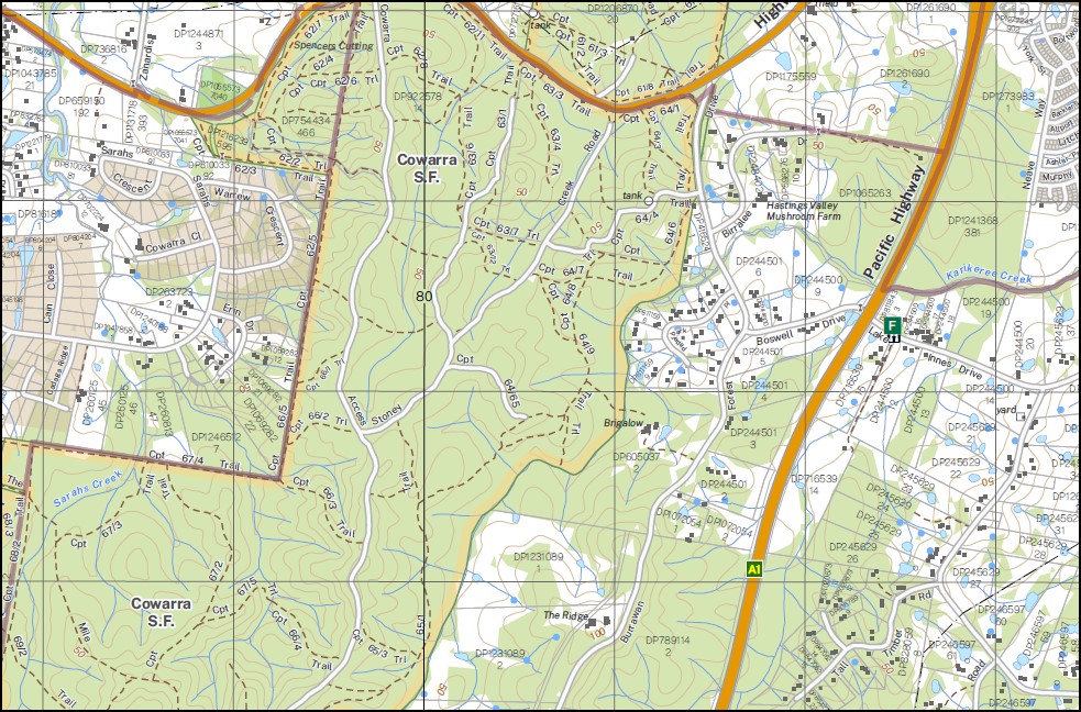
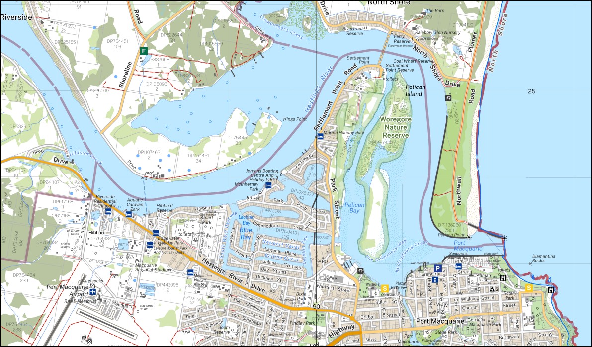
Wyandotte Ridge Riverside Tarcoola Twin Rivers Top Acre Belverdere Gaytime Sunny Corner Glenewen Indiamba Kings Point Raheen Sunnyside Lillybank Oxley Head Victoria Downs Carrington Thrumster Park Ifield Tenterden Timberline Dor Lodge Glenalan Wauchope House Dungowan Farm Touchwood Parsons Ridge Marbuk Park Port Macquarie Ana Branch Hastings River Balyngara Branch Balyngara Creek The Bay Blackmans Point Bird Rock Carecorara Inlet Caswell Channel Croppys Hill Fernbank Creek Flat Rock Flynns Beach Flynns Point Gaol Point Green Mound Green Point Hastings Public School Haydons Creek Hibbard Hughes Inlet Hursley Hursley Creek Lake Innes Innes Swamp Innesvale Carecorara Creek Flagstaff Kooloonbung Creek Lake Innes Nature Reserve Lake Swamp Lighthouse Creek Lighthouse Gully Limeburners Creek Nature Reserve Little Rawdon Island Macquarie Miners Beach Munns Channel Naret Creek Narrowgut Nobby Head Nobbys Beach North Point North Shore Oxleys Beach Partridge Creek Pelican Island Pelican Point Pembrooke Pembrooke Public School Pembrooke Railway Station Port Macquarie High School Port Macquarie Public School Putunga Rock Quetta Island Rawdon Island North Rawdon Island Creek Rawdon Island Rawdon Creek Rawdon Channel Redbank Rocky Beach Salt Water Creek Sancrox Sandy Point Sarahs Creek Settlement Point Shelly Beach Stoney Creek Tacking Point Thrumster Town Beach Transit Hill Wallace Island Watonga Rock Wotonga Rock Westport High School Westport Public School Wrights Creek Wrights Lookout Burrawan Burrowan Byrnes Brook Bellangry Park Diamantina Rocks Glebe Park Hibbard Creek John Downes Park Kingfisher Park Lions Lookout Mcinherney Park Macquarie Nature Reserve Port Macquarie Airport Port Macquarie Cemetery Port Macquarie Dam Port Macquarie Lions Lookout Port Macquarie Park Rosendahl Reserve Rosendahl Reservoir Sancrox Reserve Sea Acres Nature Reserve Stewarts Park Stuart Park The John Downes Remembrance Park Tommy Owens Creek Treetop Park Westport Park Windmill Hill Port Macquarie Historic Cemetery Rosendahl Pelican Bay Dolphin Key Calwalla Reserve Mimosa Park The Governors Way South West Passage Blue Bay Crescent Arm Southern Cove Newport Canal Ballina Canal Lachlan Bay Blair Reserve Jean Starr Reserve Ferry Reserve Fishermans Reserve Inlet Reserve Coal Wharf Reserve Riverfront Reserve Findlay Park Rotary Park Port Macquarie College Settlement City Post Office Allman Hill John Dick Reserve James Martin Reserve Mrs Yorks Garden Absalom Reserve Rocky Beach Lookout Tacking Point Public School Arthurs Park Holmes Reserve Hakea Park Sandhurst Reserve Port Macquarie Lighthouse North East Public School of Distance Education Loggy Creek Pembroke South Arm Stony Creek North Arm Stony Creek Stony Creek Maria River Hastings River Limeburners Creek Carecorana Creek Oxley Beach Cattle Brook Creek Lilly Bank Narran River Lake Burrawan The Lake Swamp
| Name: | Port Macquarie |
| Publisher: | New South Wales Government |
| Scale: | 1:25,000 |
| Latitude Range: | 31° 22.5′ S – 31° 30.0′ S |
| Longitude Range: | 152° 45.0′ E – 153° 0.0′ E |
| Datum: | GDA 2020
Edition 2025 |
| Approx Print Size: | 0.56m X 1.11m |
You may also like…
-
Telegraph Point 1-25,000 NSW Topo Map 9435-2-N
Price range: $16.95 through $28.95Select options This product has multiple variants. The options may be chosen on the product page -
Ballengarra 1-25,000 NSW Topographic Map 9435-3-N
Price range: $16.95 through $28.95Select options This product has multiple variants. The options may be chosen on the product page -
Kempsey 1-25,000 NSW Topographic Map 9435-1-N
Price range: $16.95 through $28.95Select options This product has multiple variants. The options may be chosen on the product page -
Sherwood 1-25,000 NSW Topographic Map 9435-4-N
Price range: $16.95 through $28.95Select options This product has multiple variants. The options may be chosen on the product page -
Bathurst 1-250,000 Topographic Map GA
Price range: $15.95 through $27.95Select options This product has multiple variants. The options may be chosen on the product page -
Kundabung 1-25,000 NSW Topographic Map 9435-1-S
Price range: $16.95 through $28.95Select options This product has multiple variants. The options may be chosen on the product page