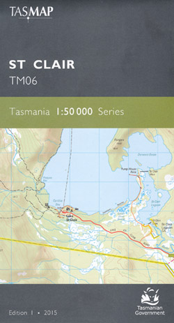
St Clair 1-50,000 Topographic Map Tasmap
$13.95
4 in stock
Description:
St Clair 1-50,000 Tasmap Topographic Map
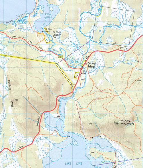
This map covers the southern portions of Walls of Jerusalem National Park and Cradle Mountain Lake St Clair National Park. As this region is remote, elevated and exposed to highland weather events the map is an essential navigation aid for walkers and wilderness fisherman accessing the lakes west of Bronte Park.
The design of the 1:50 000 Map Series will provide clear and accurate portrayal of topographic information, with symbols and map content giving enhanced depiction of buildings, hill shading and a simplified classification of vegetation.
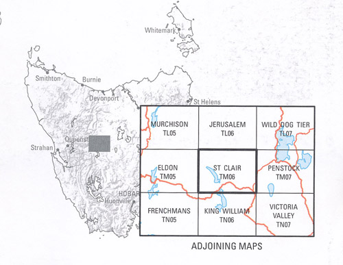
Locations within this Map
Doughboy Opening Doughboys Hill Du Cane Gap Du Cane Range Dyes Marsh Dyes Rivulet Eagle Lake Echo Point Australia Tarn Bawleys Peak Bedlam Wall Bens Marsh Bethune Creek Big Gun Pass Big Nive Rivulet Bowling Green Broken Leg Creek Bronte Bronte Bay Bronte Canal Bronte Dam Bronte Flume Bronte Park Brown Marsh Creek Bull Hill Bull Lagoons Burburys Lookout Burrow Lagoon Burstgall Hill Byron Gap Campfire Creek Castle Crag Cephissus Creek Cephissus Falls Chigah Lake Chummy Lake Circular Marsh Clarence Lagoon Clarence Pipeline Clarence River Clarence Weir Clarke Falls Coates Creek Cuppa Lake Currant Bush Shore Cuvier River Cuvier Valley Cyane Lake Cynthia Bay Deep Shore Derwent Basin Derwent Bridge Falling Mountain Feather Creek Feather Falls Fergus Bluff Fergys Hill Flexmores Marsh Flood Creek Forgotten Lake Frankland Beaches Franklin Tarns Gravestone Marsh Gable Hill Golden Cloud Swamp Gould Plateau Halfmoon Marsh Halls Island Hamilton Creek Hartnett Falls Hugel River Ida Bay Ina Lagoon Jacks Gap Johnsons Lagoon Junction Lake Kenneth Creek Kenneth Lagoon Kita Lake Lake Artemis Lake Athena Lake Beatrix Lake Catherine Lake Denton Lake Dixon Lake Elysia Lake Eros Lake Erytheia Lake Eve Lake Flora Lake Helen Lake Hermione Lake Ina Lake Ingrid Lake Jackie Lake Joan Lake Kaljee Lake Kellatie Lake Laura Lake Lenone Lake Leuce Lake Linnhe Lake Loretta Lake Lula Lake Malbena Lake Merope Lake Mikany Lake Mingundie Lake Naomi Lake Nive Lake Norman Lake Nugetena Lake Oenone Lake Olive Lake Ophion Lake Pallas Lake Payanna Lake Petrarch Lake Pogana Lake Riengeena Lake Sappho Lake Selene Lake Solitude Lake St Clair Lake Tiddler Lake Undine Lake Youd Lamonts Lookout Laughing Jack Dam Laughing Jack Lagoon Laughing Jack Marsh Layatinna Hill Lees Creek Leg o Mutton Marsh Ling Roth Lakes Little Hugel Little Navarre River Little Nive Rivulet Little Pine Marsh Little Pine River Little River Marion Creek Mary Tarn Mayfield Flats McCoy Falls Moraine Creek Mount Byron Mount Charles Mount Geryon Mount Gould Mount Hugel Mount Ida Mount Oana Mount Olympus Mount Orthys Mount Rufus Mount Spurling Mountains of Jupiter Narcissus Bay Narcissus River Navarre Plains Navarre River Never Never Lookout Nichols Junction Nive Lagoon Nive Plains Nivelle Rivulet Olive Lagoon Orion Lakes Orites Falls Pats Tarn Penelope Creek Pine River Pine Tier Dam Pine Tier Lagoon Pine Valley Pool Of Memories Powers Creek Pump House Point Rainbow End Rim Lake Rufus Canal Serpentine Rivulet Serpentine Rivulet Weir Seven Apostles Shadow Lake Skullbone Plains Spear Creek St Clair Dam St Clair Lagoon St Clair Lagoon Conservation Area St Clair Weir Stile Corner Stony Creek Surveyors Memorial Reserve Tailers Bay The Acropolis The Cellars The Chimera The Gatepost The Hippogriff The Minotaur The Never Never The Park The Parthenon Tibbs Plain Traveller Range Travellers Rest Lagoon Travellers Rest Lake Travellers Rest River Triangle Lake Watersmeet Woodwards Creek Woolshed Swamp Bronte Canal Bridge Brown Marsh Creek Bridge Clarence River Bridge Coates Creek Bridge Derwent Bridge Conservation Area Geryon Camp Gowan Brae Halls Gap Home Reach Iris Creek Joes Bay Kenneth Tier King William Plain Lake Dione Lake St Clair Tourist Road Bridge Lake Themis Little Navarre River Bridge Marlborough Middle Lake Nive River Bridge Platypus Bay Ringwood Bank River Derwent Bridge Road Shore Serpentine River Bridge Kiaora Creek Ducane Range Lake Lemoine Little Nive River Lake Petrach Lake Saint Clair Hugel Creek Serpentine Creek Bedlam Walls
| Name: | St Clair |
| Publisher: | Tasmanian State Government |
| Scale: | 1 : 50000 |
| Latitude Range: | 41° 54.47′ S – 42° 10.87′ S |
| Longitude Range: | 146° 1.88′ E – 146° 31.06′ E |
| Format: | Folded Map |
| Approx Print Size: | 0.61m X 1.08m |
| Publication Date: | 2015 |