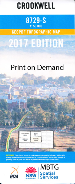
Crookwell 1-50000 NSW Topographic Map
Price range: $16.95 through $31.95
Description:
Crookwell 8729-S 1-50,000 scale NSW Topographical map is used for Walking, 4WD, Fishing, Camping, Motorcycle, both On and Off Road, Gold Prospecting and for those simply going for a family weekend drive.
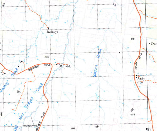
Topographical maps show not only Contours of the Terrain but also Walking Tracks, Sealed and Unsealed Roads, Rivers, Creeks, Lakes, Historical Point of Interest, Old Mine Sites and National and State Park areas.
 We can Now LAMINATE and fold your map for $12.00. Just click on the image and add to the Trolley
NOW AVAILABLE PRINT ON DEMAND
Locations within this Map
Wondokai Willow Dam Wongalea Mycumbene Little Hill Taloa Koala Eureka Westwood Callaba Baroona Sylvia Vale Lower Sylvia Vale Funny Hill Kenilworth Eunony Julong Cherryford Jessmondeen Bimbadeen Lugarno Moorabinda Beaumont Bindawalla Table Top Cumberoona Chatsworth South Nyabank Corringle Chain of Ponds Red Ground By Chance Wallah Aubynvale Hollywood Mount Henry James Park Loch Hill Avalon Evermore Windermere Hillside Sunnyside Shepherds Lodge Minto Park Woodlands Red Hill Greentop Riverview Tiwarrie Beltana Rosedale Woodford Rose Hill Willow Bank Cabarita Pine Ville Bareena Ti-Tree Crookwell Back Creek Bald Hill Bald Hill Creek Belmore Black Springs Binda Creek Binda Public School Binda Binda Cemetery Boobalaga Bramah Broken Back Creek Brooklands Chummies Creek Clear Creek Coglan Creek Coleman Park Cotton Vale Creek Cramp Crookwell Cemetery Crookwell Dam Crookwell High School Crookwell Post Office Crookwell Public School Crookwell River Deep Creek Deep Gully Denbigh Five Mile Creek Five Mile Ridge Flanagans Creek Fullers Gully Funny Hill Swamp Gibsons Creek Glenerin Grassy Creek Green Creek High Slate Hill Horse Flat Jamiesons Creek Jerrara Jerrara Creek Jonathans Flat Julong Creek Kangaloolah Kangaloolah Creek Kenset Creek Kentgrove Creek Kerns Creek Chain of Ponds Creek Crookwell Primary School Deer Creek The Deep Creek Deep Watercourse Eastern Branch of Jerrara Creek Filders Gully Kiamma Creek King Laggan Lambing Creek Lambing Shed Creek Larkhans Branch Larkhams Gully Lawless Spring Creek L’Estrange Licking Hole Gully Licking Hole Creek Little Diamond Creek Long Swamp Creek Long Nose Creek Long Nose Flat Long Nose Range Long Nose Ridge The Long Swamp Martins Springs Memorial Park Mewburn Cemetery Morrice Gully Mullengrove Narrawa Narrawa Creek Narrawa Mount Narrawa Mountain Neds Creek Old Man Gunyah Creek Old Nare Creek Old Mares Gully Parkers Branch Parkers Gully Potten Creek Rabnor Railway Park Redground Redground Creek Rogers Creek Romner Rugby Rugby Public School Sapling Creek Sawpit Creek Sawpit Gully Sawyers Creek Spring Creek Stony Creek Sylvia Creek Taylors Flat Teatree Creek The Basin The Round Water Hole Ti-Tree Creek Turkey Hill Wades Hill Wallah Wallah Wallah Wallah Creek Warns Creek Warns Gully Wattman Wheeo Wheeo Creek Whinstone Hill Whinstone Knoll Winduella Diamond Creek Diggers Gully Dodds Creek Duck Creek Bunnaby Burrawinda Creek Todkill Park Willis Park Binda Vale Creek The Gap Broad Flat Lost River Bushrangers Gully Pat Cullen Reserve Phils River Mount Narrawa Rosscommon Medways Prestons Creek
| Name: | Crookwell |
| Publisher: | New South Wales Government |
| Scale: | 1:50000 |
| Latitude Range: | 34° 15.0′ S – 34° 30.0′ S |
| Longitude Range: | 149° 0.0′ E – 149° 30.0′ E |
| Datum: | GDA 94 |