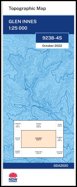
Glen Innes 1-25,000 NSW Topographic Map 9238-4-S
Price range: $16.95 through $28.95
Description:
Glen Innes 1-25,000 NSW Topographic Map 9238-4-S Print on Demand
Locations within this Map
Nolimba Wangalee Reddestone Eastview Lonewood Truro Cavillon Glenbrook Dalriada Lensby Plain View Crossmaglen Heifer Hill Osterley Rutherglen Yirri North Burrawong Tautiona Karoola Falkland Marilla Avoca Clarevaulx Virginia Roscrea Fruin Glen Kaymo Beylon Canawindra Cheven Downfield Trana Wattle Vale Euroa Hillcrest Calala Clairville Glen View Wembley Park High Fields Tauranga Waterloo Evergreen Fassifern Rose Hill Girrahween Westfield Spring Hill Ellerslie The Poplars Glen Dhu Adavale Quabadee Willow Glen Glengarry Appletrees Glen Innes A.F. Robertson Cunninghame Park Anzac Park Boyds Creek Boyds Gully Buckley Town of Wellingrove Carpenters Carpenters Hill Chaffeys Hill Cockatoo Knob Coronation Park Five Mile Creek Fuller Furracabad Glen Innes Airport Glen Innes High School Glen Innes Post Office Glen Innes Public School Glen Innes Railway Station Glen Innes West Infants School Hamels Gully Five Mile Gully Town of Glen Innes Hawthorne Gully Kerry Mead Rugby League Park Nb King Edward Park King George V Park Kingsland Lynch Oval Maids Valley Creek Martins Lookout Matheson Mead Memorial Park Mead Park Mellings Park Moonies Hill Moonies Mount Pine Creek Punchs Creek Punchs Gully Quota Park Red Glen Public School Red Rock Red Rock Ridge Robertson Cunninghame Park Rocky Ponds Creek The Rocky Ponds Rural Sandy Creek Sinclair Lookout Small Creek Smalls Creek Spine Kop Spion Kop Spring Gully The Tank Swamp Veness Park Veness Memorial Park Wellingrove Wilson Park Ditmas Donnellys Creek Dr Lynch Memorial Oval Dorothy Mellings Park Kerry Mead Rugby League Park
| Name: | Glen Innes |
| Publisher: | New South Wales Government |
| Scale: | 1:25,000 |
| Latitude Range: | 29° 37.5′ S – 29° 45.0′ S |
| Longitude Range: | 151° 30.0′ E – 151° 45.0′ E |
| Datum: | GDA 2020
Edition 2022 |
| Approx Print Size: | 0.56m X 1.11m |
You may also like…
-
Maybole 1-25,000 NSW Topographic Map 9238-3-S
Price range: $16.95 through $28.95Select options This product has multiple variants. The options may be chosen on the product page -
Mount Slow 1-25,000 NSW Topographic Map 9238-2-S
Price range: $16.95 through $28.95Select options This product has multiple variants. The options may be chosen on the product page -
Dundee 1-25,000 NSW Topographic Map 9238-1-N
Price range: $16.95 through $28.95Select options This product has multiple variants. The options may be chosen on the product page -
Rangers Valley 1-25,000 NSW Topo Map 9238-4-N
Price range: $16.95 through $28.95Select options This product has multiple variants. The options may be chosen on the product page -
Stonehenge 1-25,000 NSW Topographic Map 9238-3-N
Price range: $16.95 through $28.95Select options This product has multiple variants. The options may be chosen on the product page -
Red Range 1-25,000 NSW Topographic Map 9238-2-N
Price range: $16.95 through $28.95Select options This product has multiple variants. The options may be chosen on the product page