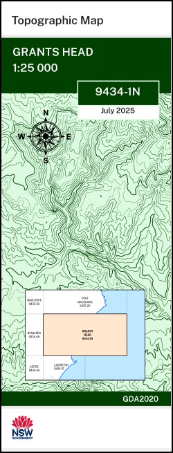


Grants Head 1-25,000 NSW Topographic Map 9434-1-N
Price range: $16.95 through $28.95
Description:
Grants Head 1-25,000 NSW Topographic Map 9434-1-N Print on Demand
Honeysuckle Roseneath Glen-Nokee River View Namguya Bonny Hills Lake Cathie Bartletts Beach Bobs Creek Christmas Bell Plain Cowarra Creek Cowarra State Forest Cutty Creek Grants Beach Grants Head Greenhills Gully Jolly Nose Hill Jolly Cathie Lake Cathie Plain Five Mile Creek Greenhills Creek Jolly Nose Rocks Lighthouse Beach Limeburners Creek Limeburners Flat Middle Rock Middle Rock Point North Beach Queens Lake Queens Lake State Forest Rainbow Beach Sapling Creek Spring Creek Spring Gully Ten Mile Gully Waterloo Creek Wrights Creek Yellow Creek Yellow Gully Duchess Gully Duchess Creek Burrawan Burrawan State Forest Cathie Creek Diggers Hill Flora Reserve Goats Island Aqua Reserve Jabiru Reserve Foreshore Reserve Karikeree Creek Jolly Nose Jonathan Dickson Reserve Nana Klumpp Reserve The Lake Swamp The Rock Herons Creek
| Name: | Grants Head |
| Publisher: | New South Wales Government |
| Scale: | 1:2,5000 |
| Latitude Range: | 31° 30.0′ S – 31° 37.5′ S |
| Longitude Range: | 152° 45.0′ E – 153° 0.0′ E |
| Datum: | GDA 2020
Edition 2025 |
| Approx Print Size: | 0.56m X 1.11m |
You may also like…
-
Laurieton 1-25,000 NSW Topographic Map 9434-1-S
Price range: $16.95 through $28.95Select options This product has multiple variants. The options may be chosen on the product page -
Lorne 1-25,000 NSW Topographic Map 9434-4-S
Price range: $16.95 through $28.95Select options This product has multiple variants. The options may be chosen on the product page