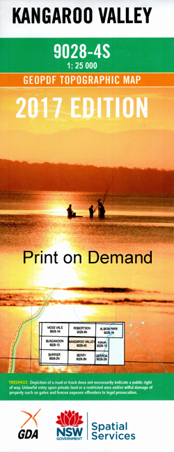
Kangaroo Valley 1-25,000 NSW Topographic Map
Price range: $16.95 through $31.95
Description:
9028-4-S NOW PRINT ON DEMAND
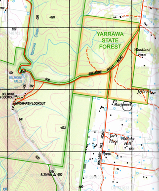
This map includes the following localities: Kangaroo Valley Barangary Creek Barrengarry Barrengarry Creek Barrengarry Pass Barren Grounds Barren Grounds Fauna Reserve Barren Grounds Nature Reserve Belmore Falls Belmore Lookout Blakemans Lookout Brogers Creek Brogers Creek (Tributary) Broughton Broughton Head Broughton Mill Creek Broughton Vale Budderoo Budderoo Creek Budderoo National Park Cabbage Tree Gully Cambewarra Cooks Nose Cooks Nose Pass Coopers Gully Coxs Pass Denners Pass Ebbs Pass Faulks Pass Flying Fox Pass Fox Fox Defence Frys Creek Gerringong Falls Gerringong Creek Hansens Pass Hindmarsh Lookout Hindmarsh Pass Hindmarsh Ridge Illawarra Lookout Jamberoo Jamberoo Pass Kangaroo Ridge Kangaroo River Kangaroo Valley Cemetery Kangaroo Valley Public School Keenans Pass Cabbage Tree Creek Coopers Creek Geringong Creek Kangaroo Range Kings Creek Kings Gully Kings Hill Range Kings Ridge Lamonds Creek Mcandrews Gap Mcevilly Lookout Majors Creek Majors Gully Mannings Gully Mannings Lookout Maynards Falls Millers Creek Minnamurra Falls Minnamurra Falls Reserve Missingham Pass Myra Hill Myra Vale Myra Mountain Myrtle Creek Myrtle Gully Nelsons Creek Osborne Osborne Park Osbornes Pass Paddys Pass Pheasants Brush Creek Powerline Pass Redbank Gully Ryders Creek Saddleback Snake Gully Stony Creek Tanners Creek Target Creek Tomlins Hill Trimbles Creek Ulrichs Pass Upper Kangaroo River Upper Kangaroo Valley Wallangunda Creek Wallaya Walshs Pass Wattamolla Watts Hill Wildes Meadow Wildes Meadow Swamp Wonga Falls Woodhill Yarrawa Yarrawa State Forest Yeola Dhruwalgha Mountain Dodds Lagoon Dodds Pass Drawing Room Rocks Bunkers Hill Burra Creek Butter Track Pass Carrington Falls Binya Hill L es Lambert Lookout Blue Gum Reserve Kokoda Wildfire Carrington Barangary Cabbage Tree
| Scale: | 1:25000 |
| Latitude Range: | 34 37.5 S – 34 45.0 S |
| Longitude Range: | 150 30.0 E – 150 45.0 E |
| Approx Print Size: | 0.56m X 1.11m |
| Projection: | Transverse Mercator |
9028-4-S
This map includes the following localities: Kangaroo Valley Barangary Creek Barrengarry Barrengarry Creek Barrengarry Pass Barren Grounds Barren Grounds Fauna Reserve Barren Grounds Nature Reserve Belmore Falls Belmore Lookout Blakemans Lookout Brogers Creek Brogers Creek (Tributary) Broughton Broughton Head Broughton Mill Creek Broughton Vale Budderoo Budderoo Creek Budderoo National Park Cabbage Tree Gully Cambewarra Cooks Nose Cooks Nose Pass Coopers Gully Coxs Pass Denners Pass Ebbs Pass Faulks Pass Flying Fox Pass Fox Fox Defence Frys Creek Gerringong Falls Gerringong Creek Hansens Pass Hindmarsh Lookout Hindmarsh Pass Hindmarsh Ridge Illawarra Lookout Jamberoo Jamberoo Pass Kangaroo Ridge Kangaroo River Kangaroo Valley Cemetery Kangaroo Valley Public School Keenans Pass Cabbage Tree Creek Coopers Creek Geringong Creek Kangaroo Range Kings Creek Kings Gully Kings Hill Range Kings Ridge Lamonds Creek Mcandrews Gap Mcevilly Lookout Majors Creek Majors Gully Mannings Gully Mannings Lookout Maynards Falls Millers Creek Minnamurra Falls Minnamurra Falls Reserve Missingham Pass Myra Hill Myra Vale Myra Mountain Myrtle Creek Myrtle Gully Nelsons Creek Osborne Osborne Park Osbornes Pass Paddys Pass Pheasants Brush Creek Powerline Pass Redbank Gully Ryders Creek Saddleback Snake Gully Stony Creek Tanners Creek Target Creek Tomlins Hill Trimbles Creek Ulrichs Pass Upper Kangaroo River Upper Kangaroo Valley Wallangunda Creek Wallaya Walshs Pass Wattamolla Watts Hill Wildes Meadow Wildes Meadow Swamp Wonga Falls Woodhill Yarrawa Yarrawa State Forest Yeola Dhruwalgha Mountain Dodds Lagoon Dodds Pass Drawing Room Rocks Bunkers Hill Burra Creek Butter Track Pass Carrington Falls Binya Hill L es Lambert Lookout Blue Gum Reserve Kokoda Wildfire Carrington Barangary Cabbage Tree
| Scale: | 1:25000 |
| Latitude Range: | 34 37.5 S – 34 45.0 S |
| Longitude Range: | 150 30.0 E – 150 45.0 E |
| Approx Print Size: | 0.56m X 1.11m |
| Projection: | Transverse Mercator |