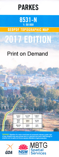
Parkes 1-50000 NSW Topographic Map
Price range: $16.95 through $31.95
Description:
8531-N Print on Demand
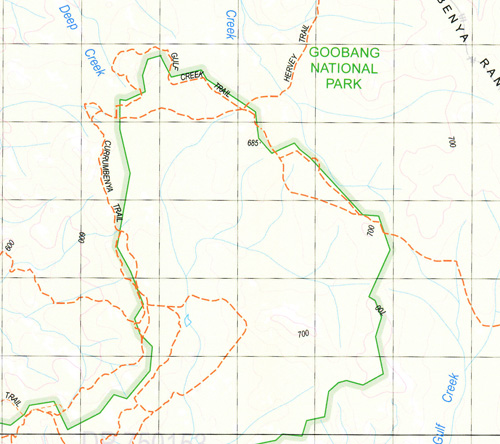
Woodlands Killare Eurona Wendooree Tradewinds Myrtle Farm Mossburn Valley View Copper Ridge Oriel Fermanagh Cardiff Walma Burnley Cooks Myalls The Secrets Mona Leigh Olieview Rendezvous Wilga Yarrimbah Trelawney Kirkup Hillview Wendouree Timaroo Warrawee Oklahoma Avon Downs Woodside Jubilee Farm Top Valley Hill Top Rocky Rise Willow Vale Poplar Grove Springvale Lumeah Rustle Glen Bundaleer Alamar Battlefield Thirlmere Woodburn Ladysmith Big Valley Hillcrest Oaklands Darinleigh Glenree Holmwood Wolabler Stockleigh Swan Hill Jindalee Rockview Pine Lodge Harvonne Glencoe Austinmere Glenwillyan Kimbar Wattle View Fern Hill Sunny Brae Blue Springs Woodbine Allengrove Westwood Thurlstone Silver Row Clear Hills Woodbine Park Queant Bryngola Nedlands Heatherleigh Pine Park Rosewood Heathcote Moura Pineview Ancrum Willow Farm Parkes Armstrong Park Allbranch Back Creek Back Goobang Creek Bartleys Creek Bartleys or Flagstone Creek Beargamil Beargamil Creek Beargamil Dam Beargamil Public School Bentley Bentleys Hill Billabong Creek Billabong West Billy Goat Range Billygoat Ridge Bindogundra Bindogundra Creek Bindogandri Bindogandri Creek Mount Boulton Box Camp Creek Brolgan Brolgan Plain Camp Gully Cheney Park Clarinda Clarinda Public School Cookamidgera Cookamidgera Cemetery Cookamidgera State Forest Cooke Park Coonambro Mount Coonambro Crooked Creek Currajong Curumbenya Curumbenya Gulf Dans Lagoon Deep Lead Dungeon Creek Endeavour Dam Lake Endeavour Gillgilbury Creek Goobang Goobang Creek Goonumbla Gulf Creek Gunningbland Huies Gully Kamandra Keast Park Kelly Reserve Camp Creek Chamberlain Square Coobang Village of Cookamidgera Cooks Myall Edward Mcglynn Park The Gap Goobang Public School The Gulf Gumble Huies Creek Kains Dam Lake Endeavour Dam Limestone Plains Limestone Plains Creek McGlynn Park Mcgregors Gilgies Mcgregors Reef or No Mistake Mandagery Public School Martin Meigel Memorial Hill Memorial Hill Lookout Lake Metcalfe Middleton Middleton Public School Millers Hill Millers Lookout Mount Gamar Mount Gaindri Moura Creek Moura or Waterhole Creek Mugincoble Myall Creek Nanardine No Mistake Town of Parkes Parkes Airport Parkesborough Parkes Cemetery Parkes General Cemetery Parkes High School Parkes Primary School Parkes National Forest Parkes Post Office Parkes Public School Parkes Racecourse Parkes Railway Station Parkes Rifle Range Parkes Showground Parkes Technical College Parkes West Public School Pine Hill Quart Pot Creek Quart Pot Gully Ridgey Creek Rocky Creek Sandy Creek Shallow Rush Snake Gully Sparlings Swamp Spicer Park Spurlings Swamp Stony Creek Stony Hill The Bumberrys The Dungeons The Welcome Lead Tichbourne The Twins Warregal Waterfall Creek Waterhole Creek Welcome Westview Public School Wolabler Mountain Woodward Park Bumberry Bumberry Cemetery Bumberry Creek Bumberry Dam Bumberry Dam Recreation Area Bumberry Range Bumberry Ridge Bumberry Ridges Bumberry State Forest Bunbury Bunbury General Cemetery Bunbury State Forest Bushmans Dam Bushmans Hill Bumberry Flora Reserve Hillclimb Tom Perry Park Coobang Creek Bogan River Nash Hill Mandagery Tichborne Mount Gamdri Curumbenya Range East Goonimbla Tank Kamandra Weir Nelungaloo Crokers Range Cooks Creek Fairview Flagstone Creek
| Name: | Parkes |
| Publisher: | New South Wales Government |
| Scale: | 1:50000 |
| Latitude Range: | 33° 00.0′ S – 33° 15.0′ S |
| Longitude Range: | 148° 0.0′ E – 148° 30.0′ E |
| Datum: | GDA 94 |
| Approx Print Size: | 0.56m X 1.11m |