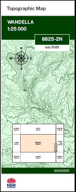


Wandella 1-25,000 NSW Topographic Map 8825-2-N
Price range: $16.95 through $28.95
Description:
Wandella 1-25,000 NSW Topographic Map 8825-2-N Print on Demand
Locations within this Map
Bobs Waterhole Fern Creek Galba Galba Creek Illawambra Dam Jeffers Jeffers Mountain Jimmys Creek Fern Gully The Gap Illawambra Creek Narira Narira Gap Narira Mountain Paddys Creek Peak Hill Swamp Rixons Hill Rixons Ridge Sams Range Sams Ridge Sam Woods Creek Sam Woods Gully Sandy Creek Stony Creek Tanto Creek Wandella Wandella Creek Wandella State Forest Wandellow Wandellow Creek Wilgo Creek Dignams Creek Dignams Hill Yourie Yowrie Dogtrap Gully Dray Road Swamp Duck Hole Duck Hole Swamp Mount Dumpling Dogtrap Creek The Dumpling Paddys Creek Flora Reserve Duck Hole Creek Peak Alone Wandello Rosebank Coleville
| Name: | Wandella |
| Publisher: | New South Wales Government |
| Scale: | 1:25,000 |
| Latitude Range: | 36° 15.0′ S – 36° 22.5′ S |
| Longitude Range: | 149° 45.0′ E – 150° 0.0′ E |
| Datum: | GDA 2020
Edition 2025 |
| Approx Print Size: | 0.56m X 1.11m |
Read More
You may also like…
-
Yowrie 1-25,000 NSW Topographic Map 8825-3-N
Price range: $16.95 through $28.95Select options This product has multiple variants. The options may be chosen on the product page -
Puen Buen 1-25,000 NSW Topographic Map 8825-3-S
Price range: $16.95 through $28.95Select options This product has multiple variants. The options may be chosen on the product page -
Cobargo 1-25,000 NSW Topographic Map 8825-2-S
Price range: $16.95 through $29.95Select options This product has multiple variants. The options may be chosen on the product page -
Cadgee 1-25,000 NSW Topographic Map 8825-1-S
Price range: $16.95 through $29.95Select options This product has multiple variants. The options may be chosen on the product page