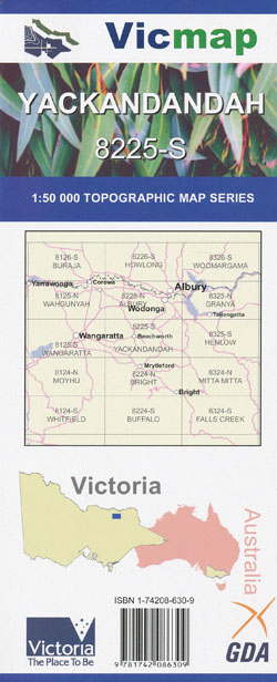
Yackandandah 1-50,000 Vicmap
Price range: $12.00 through $24.00
Description:
Yackandandah 1-50,000 scale Vicmap Topographical map 7225S is used for Walking, 4WD, Fishing, Camping, Motorcycle, both On and Off Road, Gold Prospecting and for those simply going for a family weekend drive.
Topographical maps show not only Contours of the Terrain but Walking Tracks, Sealed and Unsealed Roads, Rivers, Creeks, Lakes, Historical Points of Interest, Old Mine Sites mbtg and National and State Park areas.
Main Features of this map includes:
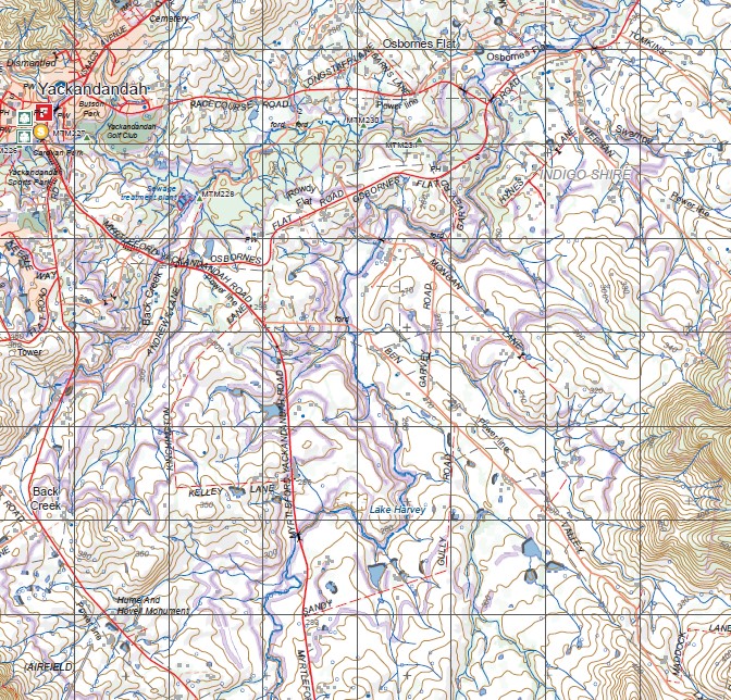
Yackandandah, Beechworth, Chiltern, Eldorado, Stanley, Everton, Ovens River, Whorouly, Allans Flat, Mount Murramurrangbong, Mount Big Ben, Mount Jack, Reides Creek, Nine Mile Creek HR, Murmungee, Mudgegonga, Mount Stanley, mbtg, Chiltern Mount Pilot National Park, South Western corner of the Chiltern Pilot National Park, Mount Baranduda, Staghorn Flat, Mount Murramurrangboong, Allans Flat, Osbournes Flat, Twist Creek, Stanley State Forest, Kirby Flat, Doctor Flat, Lake Harvey, Back Creek, Walaby Mine Kerry Eagle Mine, Rechabite Mine, Hume and Hovell Monument, mbtg, Stanley State Forest, Stringer Ridge, Kangaroo Ridge, Stanley, Hume And Hovell Monument, Mount Stanley, Kangaroo Ridge, Stanley Plantation, Devils Elbow Gap, Mudgegonga, Bruarong, Glen Creek, Mount Jack, Mount Big Ben, Dederang Terminal Station
Beechworth, Eldorado, Reids Creek, Northern Section of the Chiltern Pilot National Park, Tarrawingee, Barombogie State Forest, Native Dog Peak, Beechworth Correctional Centre, Woolshed Falls, Clear Creek Falls, Woolshed, Mount Pilot, Lake Kerferd, Nine Mile Creek Historic Region, Wooragee, mbtg, Everton, Baarmutha, Tarrawingee, Brookfield, MURMUNGEE, WHOROULY SSR, Whorouly, Bowmans Forest, Taylor Gap, CUNNINGHAM GULLY HR, part of the Stanley State Forest, Dingle Plantation
ISBN 9781742086309
You may also like…
-
Beechworth Albury Wangaratta Adventure Map Rooftop
Price range: $11.95 through $25.00Select options This product has multiple variants. The options may be chosen on the product page -
Albury 1-50,000 Vicmap
Price range: $12.00 through $24.00Select options This product has multiple variants. The options may be chosen on the product page -
Bright 1-50,000 Vicmap
Price range: $12.00 through $24.00Select options This product has multiple variants. The options may be chosen on the product page -
Mitta Mitta 1-50,000 Vicmap
Price range: $12.00 through $24.00Select options This product has multiple variants. The options may be chosen on the product page -
Moyhu 1-50,000 Vicmap
Price range: $12.00 through $24.00Select options This product has multiple variants. The options may be chosen on the product page -
Yackandandah 1-50000 Geological Map Victoria
Price range: $16.95 through $31.95Select options This product has multiple variants. The options may be chosen on the product page -
Granya 1-50,000 Vicmap Topographic Map 8325-N
Price range: $12.00 through $24.00Select options This product has multiple variants. The options may be chosen on the product page -
BEECHWORTH NORTH 1-25,000 Vicmap Topo 8225-3-N
Price range: $14.00 through $26.00Select options This product has multiple variants. The options may be chosen on the product page -
YACKANDANDAH SOUTH 1-25,000 Vicmap Topo 8225-2-S
Price range: $14.00 through $26.00Select options This product has multiple variants. The options may be chosen on the product page -
Henlow 1-50,000 Vicmap
Price range: $12.00 through $24.00Select options This product has multiple variants. The options may be chosen on the product page -
Wahgunyah 1-50,000 Vicmap
Price range: $12.00 through $24.00Select options This product has multiple variants. The options may be chosen on the product page -
YACKANDANDAH NORTH 1-25,000 Vicmap Topo 8225-2-N
Price range: $14.00 through $26.00Select options This product has multiple variants. The options may be chosen on the product page -
Wangaratta 1-50,000 Vicmap
Price range: $12.00 through $24.00Select options This product has multiple variants. The options may be chosen on the product page -
BEECHWORTH SOUTH 1-25,000 Vicmap Topo 8225-3-S
Price range: $14.00 through $26.00Select options This product has multiple variants. The options may be chosen on the product page