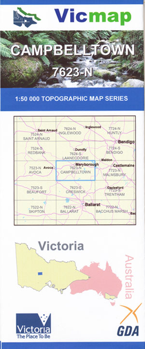
Campbelltown 1-50,000 Vicmap Topo Map 7623-N
Price range: $14.00 through $26.00
Description:
Campbelltown 1-50,000 scale Vicmap Topographical map 7623N is used for Walking, 4WD, Fishing, Camping, Motorcycle, both On and Off Road, Gold Prospecting and for those simply going for a family weekend drive.
Topographical maps show not only Contours of the Terrain but Walking Tracks, Sealed and Unsealed Roads, Rivers, Creeks, Lakes, Historical Point of Interest, Old Mine Sites mbtg and National and State Park areas.
Main Features of this map includes:
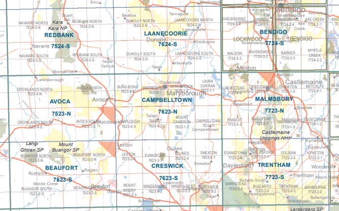
Maryborough, Campbelltown, Talbot, Carisbrook townships
Cairn Curran Reservoir, Golden Point, Ctaigie, Majorca, Chalks Freehold Mine, HAVELOCK NCR, MOUNT MOOLORT, TULLAROOP RESERVOIR, Victorian Estates 1 Mine, Sandon State Forest, Joyces Creek, Keystone Mine, mbtg, Campbelltown, Mount Cameron, Eglington State Forest, Mount Glasgow, MERIN MERIN & MIDDLE SWAMP WR, Clunes Ste Forest, TULLAROOP CREEK SSR, TULLAROOP RESERVOIR, MOUNT DUNTRULM, Glengower, Strathlea, Sandon State Forest
Maryborough, Bung Bong, Lower Homebush, Working Miners United Main Mine, North Homebush Mine, Homebush, Glenmona State Forest, Sydney Hill Reef (Sydney Reef) Mine, Paddy Ranges – Daisy Hill State Forest, Bung Bong NCR, Moores Flat, Bet Bet Creek, Wareek State Forest, Reliance (Robin Hood) Mine, Camping Area (Adjacent To Karri Track), ADELAIDE LEAD SSR, Moonlight Flat, INKERMAN LEAD BR, Alma, INKERMAN LEAD BR, Timor State Forest, SEAHAM MINE BR, ALMA LEAD CYANIDE WORKS HR, Daisy Hill, part of the Craigie Stat Forest, mbtg, Talbot, Amherst, Lamplough, Glenmona State Forest, Lillicur, DULAPWHANG WATERHOLES SSR, Paddy Ranges -Daisy Hill State Forest, BUNG BONG NCR, Bung Bong – Lillicur State Forest, Burnbank, mbtg, Norbury No 1 Mine, Caralulup, TALBOT NCR, AMHERST REEF GR, TUNNEL HILL, DUNACH NCR, MOUNT GREENOCK, Eglington State Forest, Eglington State Forest., Clunes State Fores
ISBN 9781742084398
You may also like…
-
Ballarat 1-250,000 Topographic Map GA
Price range: $15.95 through $27.95Select options This product has multiple variants. The options may be chosen on the product page -
Trentham 1-50,000 Vicmap
Price range: $12.00 through $24.00Select options This product has multiple variants. The options may be chosen on the product page -
Redbank 1-50,000 Vicmap Topographical Map 7524-S
Price range: $14.00 through $26.00Select options This product has multiple variants. The options may be chosen on the product page -
CAMPBELLTOWN NORTH 1-25,000 Vicmap Topo 7623-1-N
Price range: $14.00 through $26.00Select options This product has multiple variants. The options may be chosen on the product page -
Bendigo 1-50,000 Vicmap
Price range: $12.00 through $24.00Select options This product has multiple variants. The options may be chosen on the product page -
Creswick 1-50,000 Vicmap
Price range: $12.00 through $24.00Select options This product has multiple variants. The options may be chosen on the product page -
Beaufort 1-50,000 Vicmap
Price range: $12.00 through $24.00Select options This product has multiple variants. The options may be chosen on the product page -
CAMPBELLTOWN SOUTH 1-25,000 Vicmap Topo 7623-1-S
Price range: $14.00 through $26.00Select options This product has multiple variants. The options may be chosen on the product page -
Malmsbury 1-50,000 Vicmap Topographic Map
Price range: $12.00 through $24.00Select options This product has multiple variants. The options may be chosen on the product page -
Avoca 1-50,000 Vicmap
Price range: $12.00 through $24.00Select options This product has multiple variants. The options may be chosen on the product page -
Laanecoorie 1-50,000 Vicmap Topographic Map 7624-S
Price range: $14.00 through $26.00Select options This product has multiple variants. The options may be chosen on the product page -
CRESWICK NORTH 1-25,000 Vicmap Topo Map 7623-2-N
Price range: $14.00 through $26.00Select options This product has multiple variants. The options may be chosen on the product page