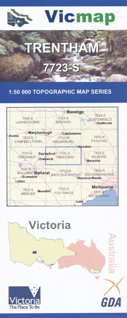
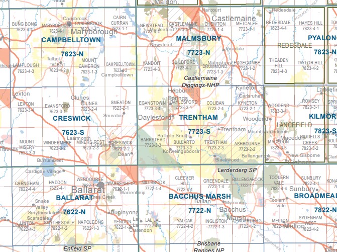
Trentham 1-50,000 Vicmap
Price range: $12.00 through $24.00
Description:
Trentham 1-50,000 scale Vicmap Topographical map 7723S is used for Walking, 4WD, Fishing, Camping, Motorcycle, both On and Off Road, Gold Prospecting and for those simply going for a family weekend drive.
Topographical maps show not only Contours of the Terrain but Walking Tracks, Sealed and Unsealed Roads, Rivers, Creeks, Lakes, Historical Points of Interest, Old Mine Sites mbtg and National and State Park areas.
Main Features of this map includes:
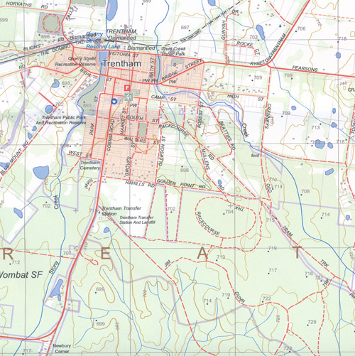
Daylesford, Trentham, Hepburn Springs, Mount Franklin, Kyneton
The top of Wombat State Forest
Kyneton, Carlsruhe, Tyledon, Kyneton South, Fern Hill, Little Hampton, Babbington Hill, Milkingyard Creek SSR, Gluepot Creek, Upper Loddon SF, Dyers Falls SR, mbtg, Lauriston Reservoir, part of the Coliban River, Upper Coliban Reservoir, Snowden Hill, Wombat SF, Kangaroo Hill, Denver BR, Kidds Hill, part of the Loddon River, mbtg, Lowes Hill, Sugarloaf Hill, Spring Hill, Tysons Gully, Spring Hill Falls, Mannings Bridge, Remeasure Track, Kelly Swamp Track, Reed Track, Henry Track, Muses Hill, Tylden South, Goodfellows Hill, Harpers Bridge, Campaspe Reservoir, mbtg, Tylden Reservoir, part of the Great Dividing Range, Lyonville Spring, Enders Hill, Trentham Falls. mbtg, Trentham, Blackwood, Ashbourne, Newbury, North Blackwood, part of the Great Dividing Range, Top of Lerderderg, Lyonville, Babbington Hill, part of Wombat State Forest, mbtg, Enders Hill, Coliban River, Cranneys Hill, Trent Creek, Quarry Street Reserve Lake, Maloney Hill, Trentham East, Milkingyard Creek, Stockyard Creek, Newbury Corner, Stanley Park Waterfall, Wild Dog Creek, Wild Dog Track, Blue Mountain Fire Lookout, mbtg, Firth Dam, Anderson Mill Walk, Campaspe Seed Orchard Plantation, Red Hill, Wombat East No 10 Track, Distal Track, Four Ways Corner, Johnson Corner, Saw Pitt Gully Falls, Barrys Reef, Anderson Corner, Blackwood Reservoir, mbtg, Shaws Lake, Diggers Track, Lerderderg Camp Ground, Ruths Gully Reference Area, Golden Point, Simmons Reef, Swinley Track, German Track, Green Hills, Obriens Crossing, Hogan Flat, Scotties Gully Track.
Daylesford, Hepbrn Springs, Dry Diggings State Forest, Mount Franklin, Mount Stewart, Eganstown, Kangaroo Hills, Kooroocheang, Glenlyon, mbtg, Bullarto, Barkstead, the edge of Newlyn and Newlyn Reservoir, Green Hill, Donnelly Hill, Billanook Hill, Rocklin, Mollongghip, Tipperary Hills, Mount Prospect, Mount Wilson, Mount Hope, Woodburn, Paddy Flat, Sailors Falls, Korweinguboora
ISBN 9781742086002
You may also like…
-
Daylesford North 1-25,000 Vicmap Topo 7723-3-N
Price range: $14.00 through $26.00Select options This product has multiple variants. The options may be chosen on the product page -
Daylesford North 1-25,000 Vicmap Topo Map 7723-3-N
Price range: $14.00 through $26.00Select options This product has multiple variants. The options may be chosen on the product page -
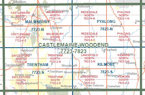
Castlemaine Woodend 1-100,000 Vicmap 7723 7823
Price range: $12.00 through $24.00Select options This product has multiple variants. The options may be chosen on the product page -
Wombat State Forest 4WD Map Meridian Edition 5
Price range: $14.95 through $26.96Select options This product has multiple variants. The options may be chosen on the product page -
Ballarat 1-50,000 Vicmap
Price range: $12.00 through $24.00Select options This product has multiple variants. The options may be chosen on the product page -
Malmsbury 1-50,000 Vicmap Topographic Map
Price range: $12.00 through $24.00Select options This product has multiple variants. The options may be chosen on the product page -
Kilmore 1-50,000 Vicmap Topographic Map 7824-S
Price range: $14.00 through $26.00Select options This product has multiple variants. The options may be chosen on the product page -
Creswick 1-50,000 Vicmap
Price range: $12.00 through $24.00Select options This product has multiple variants. The options may be chosen on the product page -
DAYLESFORD SOUTH 1-25,000 Vicmap Topo 7723-3-S
Price range: $14.00 through $26.00Select options This product has multiple variants. The options may be chosen on the product page -
TRENTHAM SOUTH 1-25,000 Vicmap Topo Map 7723-2-S
Price range: $14.00 through $26.00Select options This product has multiple variants. The options may be chosen on the product page