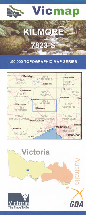
Kilmore 1-50,000 Vicmap Topographic Map 7824-S
Price range: $14.00 through $26.00
Description:
Kilmore 1-50,000 scale Vicmap Topographical map 7824S is used for Walking, 4WD, Fishing, Camping, Motorcycle, both On and Off Road, Gold Prospecting and for those simply going for a family weekend drive.
Topographical maps show not only Contours of the Terrain but Walking Tracks, Sealed and Unsealed Roads, Rivers, Creeks, Lakes, Historical Point of Interest, Old Mine Sites mbtg and National and State Park areas.
Main Features of this map include:
Kilmore, edge of Romsey, Springfield, Doggetts Bridge, Forbes Bridge, Sheehans Crossing, GALLAGHERS FORD SSR, Dalys Bridge, Number Three Creek, Goldie, Forbes, BOYDS CREEK SSR, Slab Hut Creek, Willowmavin, Bylands, Hume And Hovell Monument Tower, Kilmore East, BARASSE Hill, Bald Hills. mbtg, Wallan, Bolindavale, BROCK Hill, Monegeetta, Monegeetta North, Bolinda, Clarkefield, FENTON Hill, Chintin, Darraweit Guim, Beveridge, MOUNT FRASER, Wallan East
Woodend, Romsey, Lancefield, MOUNT DIOGENES, Hanging Rock, Carlsruhe, Cadello, MACEDON Regional Park, THE JIM JIM, Cobaw, Cobaw State Forest, Newham, CAMELS HUMP, TUNNEL CREEK NFR, Hesket, Lancefield Number One and two Reservoir, Rochford, BROCK MONUMENT, Romsey Reservoir, OCHILTREE HILL, Musteys Bridge, mbtg, Macedon, Mount Macedon, Riddells Creek, edge of Wombat State Forest, Bullengarook, northern section of Lerderderg State Park, Rosslynne Reservoir, MOUNT TOWRONG, Gisborne, New Gisborne, mbtg, Treetops Camp, CONGLOMERATE GULLY FR, Forster Reservoir, Wright Reservoir, MOUNT ROBERTSON, MOUNT TENERIFFE, MOUNT CHARLIE, Cherokee, Kerrie, TUNNEL CREEK NFR, BOLINDA CREEK SSR, Rowallan Scout Camp, Jacksons Creek Bridge, Black Hill Bridge, Clarkefield, Bolinda Bridge, Monegeetta, MONAGEETA COMMONWEALTH AREA, Mullalys Bridge, Bolinda, Monegeetta North
ISBN 9781742085074
You may also like…
-
Glenburn 1-50,000 Vicmap
Price range: $12.00 through $24.00Select options This product has multiple variants. The options may be chosen on the product page -
LANCEFIELD NORTH 1-25,000 Vicmap Topo 7823-3-N
Price range: $14.00 through $26.00Select options This product has multiple variants. The options may be chosen on the product page -
Wombat State Forest 4WD Map Meridian Edition 5
Price range: $14.95 through $26.96Select options This product has multiple variants. The options may be chosen on the product page -
Malmsbury 1-50,000 Vicmap Topographic Map
Price range: $12.00 through $24.00Select options This product has multiple variants. The options may be chosen on the product page -
KILMORE NORTH 1-25,000 Vicmap Topo Map 7823-2-N
Price range: $14.00 through $26.00Select options This product has multiple variants. The options may be chosen on the product page -
Trentham 1-50,000 Vicmap
Price range: $12.00 through $24.00Select options This product has multiple variants. The options may be chosen on the product page -
Pyalong 1-50,000 Vicmap
Price range: $12.00 through $24.00Select options This product has multiple variants. The options may be chosen on the product page -
LANCEFIELD SOUTH 1-25,000 Vicmap Topo 7823-3-S
Price range: $14.00 through $26.00Select options This product has multiple variants. The options may be chosen on the product page -
KILMORE SOUTH 1-25,000 Vicmap Topo Map 7823-2-S
Price range: $14.00 through $26.00Select options This product has multiple variants. The options may be chosen on the product page -
Castlemaine Woodend 1-100,000 Vicmap 7723 7823
Price range: $12.00 through $24.00Select options This product has multiple variants. The options may be chosen on the product page