

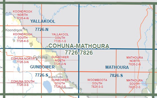
Cohuna Mathoura 1-100,000 Vicmap Topo 7726-7826
Price range: $14.00 through $26.00
Description:
Cohuna Mathoura 1-100,000 Vicmap Topographic Map 7726-7826 NOW PRINT ON DEMAND is used for Walking, 4WD, Fishing, Camping, Motorcycle, both On and Off Road, Gold Prospecting and for those simply going for a family weekend drive.
This is a new series of 1-100,000 scale maps, all of Victoria are covered by these maps.
Topographical maps show not only Contours of the Terrain but Walking Tracks, Sealed and Unsealed Roads, Rivers, Creeks, Lakes, Historical Points of Interest, Old Mine Sites and National and State Park areas.
Main Features of this map includes:
Cohuna, Mathoura, Deniliquin, Macorna, Mincha West, Johnsons Swamp, Hird Swamp mbtg, Kerand East, Milnes Bridge, Gannawarra North, Teal Point, Koondrook, Barham, Culfearne, parts of Gunbower Island, Leitchville, Gunbower, Mount Hope, Woomboota, Moira Lake, edge of Barmah and Barmah State Park
You may also like…
-
GUNBOWER SOUTH 1-25,000 Vicmap Topo Map 7726-2-S
Price range: $14.00 through $26.00Select options This product has multiple variants. The options may be chosen on the product page -
GUNBOWER NORTH 1-25,000 Vicmap Topo Map 7726-2-N
Price range: $12.00 through $24.00Select options This product has multiple variants. The options may be chosen on the product page -
Yallakool 1-50,000 Vicmap
Price range: $12.00 through $24.00Select options This product has multiple variants. The options may be chosen on the product page -
Mathoura 1-50,000 Vicmap
Price range: $12.00 through $24.00Select options This product has multiple variants. The options may be chosen on the product page -
Gunbower 1-50,000 Vicmap
Price range: $12.00 through $24.00Select options This product has multiple variants. The options may be chosen on the product page