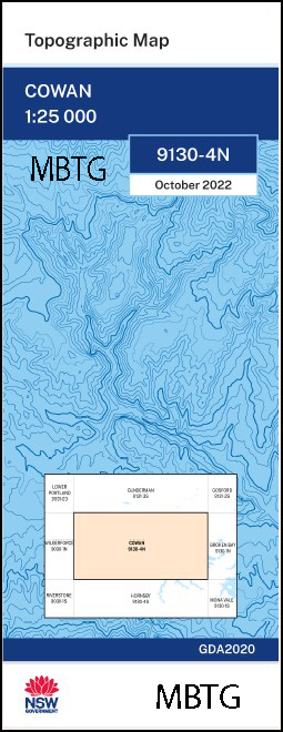

Cowan 1-25,000 NSW Topographic Map
$16.95
Description:
Cowan 1-25,000 NSW Topographic Map 9130-4-N
Cowan 1-25,000 Scale NSW Topographical Map is used for Walking, 4WD, Fishing, Camping, Motorcycle, both On and Off Road, Gold Prospecting and for those simply going for a family weekend drive.
Topographical maps show not only Contours of the Terrain but also Walking Tracks, Sealed and Unsealed Roads, Rivers, Creeks, Lakes, Historical Point of Interest, Old Mine Sites mbtg and National and State Park areas.
This map includes the following localities: Hidden Valley Brooklyn Cowan Dangar Island Glenorie Mooney Mooney Back Bay Arcadia Park Arcadia Public School Alison Point Arcadia Ants Nest Ants Nest Point Banks Creek Bar Island Bar Island Cemetery Bar Point Beauty Point Bennets Bay Benoni Wharf Berowra Berowra Creek Berowra Heights Berowra North Public School Berowra Park Berowra Public School Berowra Railway Station Berowra Reservoir Berowra Waters Berowra Waters Lookout Berrilee Berrilee Public School Berrilee Ridge Big Bay The Bluff Blanche Mount Blanche Blanche Crater Blake Ridge Blake Birrilee Birralee Bradleys Bay Bradleys Beach Brittania Rock Britannia Rock Broadarrow Broadarrow Reach Brooklyn Cemetery Brooklyn Park Brooklyn Post Office Brooklyn Public School Village of Brooklyn Brooklyn Wharf Bujwa Bay Bujwa Creek Bujwa Ridge Cabbage Point Calabash Calabash Bay Calabash Creek Calabash Point Calabash Ridge Campbell Campbells Crater castle Bay Cent Spur Cheero Point Cliff Coba Coba Bay Coba Creek Coba Point Coba Ridge Cogra Bay Cogra Hill Cogra Point Cole Collingridge Point Colo Colo Spur Cottage Point Cottage Rock Cowan Point Cowan Public School Cowan Railway Station Crossland Creek Cunio Point Dead Horse Bay Deep Bay Denny Denny Creek Devils Hole Bay Dusthole Bay Dusthole Ridge Dusthole Point Eagle Rock Edwards Eleanor Beach Eleanor Bluffs Ethel Ethel Spur Evelyn Fagan Fagan Ridge Fiddletown Fiddletown Creek Fishermans Beach Fishermans Point Fishermans Rock Flat Rock Point Folly Spur Forest Glen Public School Fosters Creek Franks Bight Franks Gully Friendly Bay Friendly Island Glenorie Creek Glenorie Oval Glenorie Park Glenorie Public School Glenorie Ridge Govett Range Govett Ridge Graces Shore Grear Green Point Gunyah Beach Gunyah Hill Gunyah Point Half Moon Bay Hall Hallets Beach Halls Creek Hawkesbury River Railway Station Hecla The Icicles Jerusalem Bay Joe Crafts Bay Joe Crafts Creek Kangaroo Point Kangaroo Point Wharf Castle Lagoon Cheerio Point Cobar Cobar Ridge Cobra Bay or Cobar Bay or Cobah Bay Colin Ridge Point Crosslands Bay Dangar Island (Mullet Island) Devils Hole Eleanor Bluff Flat Rock Goat Green Point or Cottage Point Joe Craft Creek Joe Crafts Reef John D. Tipper Lookout Kangaroo Point Public Wharf Kimmerikong Ridge Kimmerikong Bay Kimmerikong Creek Kiparra Park Kulkah Bay Ku-ring-gai Chase National Park Liptmans Little Bay Little Jerusalem Bay Little Shark Rock Point Little Wobby Beach Lloyd Gully Long Island Long Island Nature Reserve Looking Glass Bay Looking Glass Spur Lookout Bay The Lookout Mckell Park Mareela Reef Marramarra Creek Marra Marra Creek Marramarra National Park Martin Melvys Wharf Millicent Milsons Passage Milson or Mud Island Milson Island Mooney Mooney Bay Mooney Mooney Point Mooney Mooney Public School Morgans Point Mougamarra Nature Reserve Mougamarra Rydge Mud Point Mullet or Cogra Point Muogamarra Point Muogamarra Creek Muogamarra Nature Reserve Muogamarra Ridge Mount Neerim Neverfail Bay New Guinea Hill Nicholsons Creek North Branch of Charltons Creek North Cowan Oaky Point Olga Bay Mount Orient Parsley Bay Peak Hill Peat Island Peats Bight Peats Crater Pelican Island Pie Dish Hill Pinta Bay Pinta Spur Poppy Porto Bay Porto Creek Porto Gully Porto Ridge Pound Spur Prickly Point Rabbit Island Rats Castle Rose Sailors Chest Sailors Chest Point Sams Gully Sandy Bay Sandy Point Seymours Creek Shark Rock Point Shark Rock Ridge Shuttle Mount Shuttle Shuttles Bay Smugglers Ridge Snake Island South Channel Spectacle Spectacle Island Spectacle Island Nature Reserve Square Bay Sunny Corner Ridge Sunshine Bay Swallow Rock Taffys Gully Taffys Lookout Taffys Rock Tank Cove The Tanks Teatree Ten Bob Ridge The Dusthole The Gut The Gutter The Vale Tipper Lookout Trafalgar Bay Tumbledown Twin Gums The Vines Vize Vize Spur Waddell Waddell Ridge Wallaroo Want Want Spur Washtub Gully Whistling Kite Point Wideview Public School The Woolwash Wurrala Yatala Yatala Creek Yeomans Bay Yeomans Creek Yoothamurra Mount Dewrang Djarra Djarra Crossing Djarra Ridge Donnybrook Bay Double Lagoon Duckponds Ridge Djara Djara Crossing Djara Ridge The Duck Ponds Bywater Village of Bywater Ted Schwebel Park Forest Glen Sandbrook Inlet Deerubbun Reserve Sanbrook Inlet Brush Tail Creek Origma Creek Wonga Creek Finger Board Creek Banggarai Creek Racemosa Creek Campbells Creek Berowra Point Marramarra Ridge
| Scale: | 1:25000 |
| Latitude Range: | 33 30.0 S – 33 37.5 S |
| Longitude Range: | 151 00.0 E – 151 15.0 E |
| Approx Print Size: | 0.56m X 1.11m |
| Projection: | Transverse Mercator
GDA 2020 Edition 2022 |
You may also like…
-
Broken Bay 1-25,000 NSW Topographic Map
Price range: $16.95 through $28.95Select options This product has multiple variants. The options may be chosen on the product page -
Botany Bay 1-25,000 NSW Topographic Map
Price range: $16.95 through $31.95Select options This product has multiple variants. The options may be chosen on the product page -
Mona Vale 1-25,000 NSW Topographic Map 9130-1-S
Price range: $16.95 through $28.95Select options This product has multiple variants. The options may be chosen on the product page -
Parramatta River 1-25,000 NSW Topographic Map
Price range: $16.95 through $31.95Select options This product has multiple variants. The options may be chosen on the product page -
Bondi 1-25,000 NSW Topographic Map
Price range: $16.95 through $31.95Select options This product has multiple variants. The options may be chosen on the product page -
Sydney Heads 1-25,000 NSW Topographic Map
Price range: $16.95 through $31.95Select options This product has multiple variants. The options may be chosen on the product page -
Hornsby 1-25,000 NSW Topographic Map 9130-4-S
Price range: $16.95 through $28.95Select options This product has multiple variants. The options may be chosen on the product page