
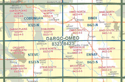
DARGO OMEO 1-100,000 Vicmap Topo 8323-8423
$14.00
Description:
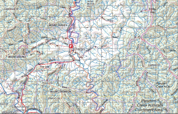
DARGO OMEO 1-100,000 Vicmap 8323-8423 NOW PRINT ON DEMAND is used for Walking, 4WD, Fishing, Camping, Motorcycle, both On and Off Road, Gold Prospecting and for those simply going for a family weekend drive.
This is a new series of 1-100,000 scale maps, all of Victoria is covered by these maps.
Topographical maps show not only Contours of the Terrain but Walking Tracks, Sealed and Unsealed Roads, Rivers, Creeks, Lakes, Historical Points of Interest, Old Mine Sites mbtg and National and State Park areas.
Main Features of this map includes:
Dargo, Omeo, Cobungra, Steve, Ensay, Bindi, Mount Little Blowhard, Mount Saint Bernard, Mount Blue Rag, Basalt Knob, Talbotville, Mount Grant, Mount Cynthia, Howittville, Crooked River, Mount Hurley, Mount Steve, Peter the Swede, Mount Ewen, MOUNT BIRREGUN, Anglers Rest, Mount Battery, Mount Phipps, Shanahan, Seldom Seen, Marthavale, Brookville, Mount Delusion, MOUNT GINGEE MUNJIE, MOUNT MUNGOBALA, Mount Livingstone, Mount Worcestor, Mount George, Bingo Munjie North, Mount Cook, Mount Jonas, Tngo Gap, Mount Tongio, Swifts Creek, Tambo Crossing, Wattle Circle, Devils Backbone, Ensay South, Mount Hopeful, Mount Hopeful, Mount McAdam, Mount Stawell, Mount Walterson, Mount Shanahan, Mount Tambo, Buchan Headwater Wilderness Zone, Nugong Range, Reedy Flat, Timbarra, Mount Elizabeth
You may also like…
-
Bairnsdale Dargo Omeo Adventure Map Rooftop
Price range: $12.95 through $25.00Select options This product has multiple variants. The options may be chosen on the product page -
STEVE NORTH 1-25,000 Vicmap Topo Map 8323-2-N
Price range: $14.00 through $26.00Select options This product has multiple variants. The options may be chosen on the product page -
Cobungra 1-50,000 Vicmap
Price range: $12.00 through $24.00Select options This product has multiple variants. The options may be chosen on the product page -
Ensay 1-50,000 Vicmap
Price range: $12.00 through $24.00Select options This product has multiple variants. The options may be chosen on the product page -
Steve 1-50,000 Vicmap
Price range: $12.00 through $24.00Select options This product has multiple variants. The options may be chosen on the product page -
Bindi 1-50,000 Vicmap
Price range: $12.00 through $24.00Select options This product has multiple variants. The options may be chosen on the product page