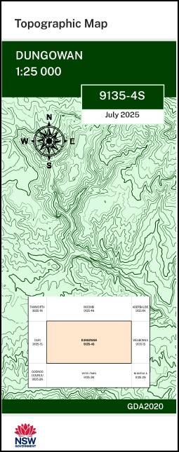


Dungowan 1-25,000 NSW Topographic Map 9135-4-S
$16.95
Description:
Dungowan 1-25,000 NSW Topographic Map 9135-4-S
Locations within this Map
Hillcrest Oatlands Strathallyn Beverley Limestone Park Ningana Ramleh Whakatane Beltana Echo Hills Kanimbla Park Burra Bru Clermont Fairlea Leconfield Lanark Unique Green Hills Artiscombe Gowan Brae Killarney Mount Erin Heatherbrae Glenrock Hawthorne Grove Hillbrook Overleigh Glenore Kwinana Lloma Wahoonga Glen Dhu Hillview Ravencroft Yallambi Bonniedoon Dungowan Station Boondaroo The Big Hill Big Hill Dungowan Georges Gully Glendower Glendower Mountain Ironbark Creek Ironbark Gully The Lagoon Loomberah Loomberah Public School Lower Dungowan Public School Monkey Creek Nemingha Creek Nemingha Public School Oaky Creek Parry Piallamore Piallamore Anabranch Piallamore Creek Red Gully Spring Creek Spring Gully Ten Mile Mulla Trough Creek Trough Gully Yellow Gully Mulla Creek Gill Hodgkiss Creek Cockburn River Mankey Creek Reedy Creek Sandy Creek Dungowan Creek
| Scale: | 1:25,000 |
| Latitude Range: | 31° 7.5′ S – 31° 15.0′ S |
| Longitude Range: | 151° 0.0′ E – 151° 15.0′ E |
| Datum: | GDA 2020
Edition 2025 |
| Approx Print Size: | 0.56m X 1.11m |
You may also like…
-
Moonbi 1-25,000 NSW Topographic Map 9135-4-N
Price range: $16.95 through $28.95Select options This product has multiple variants. The options may be chosen on the product page -
Nangala 1-25,000 NSW Topographic Map
Price range: $16.95 through $31.95Select options This product has multiple variants. The options may be chosen on the product page -
Weabonga 1-25,000 NSW Topographic Map
Price range: $16.95 through $31.95Select options This product has multiple variants. The options may be chosen on the product page -
Scott 1-25,000 NSW Topographic Map
Price range: $16.95 through $31.95Select options This product has multiple variants. The options may be chosen on the product page -
Niangala 1-25,000 NSW Topographic Map
Price range: $16.95 through $28.95Select options This product has multiple variants. The options may be chosen on the product page -
Nundle 1-25,000 NSW Topographic Map 9135-3-S
Price range: $16.95 through $28.95Select options This product has multiple variants. The options may be chosen on the product page