

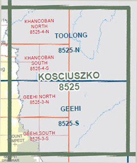

Geehi 1-50,000 Vicmap Topographical Map 8525-S
Price range: $14.00 through $26.00
Description:
Geehi 1-50,000 scale Vicmap Topographical map 8525S is used for Walking, 4WD, Fishing, Camping, Motorcycle, both On and Off Road, Gold Prospecting and for those simply going for a family weekend drive.
Topographical maps show not only Contours of the Terrain but Walking Tracks, Sealed and Unsealed Roads, Rivers, Creeks, Lakes, Historical Point of Interest, Old Mine Sites mbtg and National and State Park areas.
Main Features of this map include:
Thredbo Village, Perisher Valley, Geehi, Mount Kosciuzko, Alpine Walking Track, Biggara Bridge, MOUNT BUNROY, BUNROY Gap, edge of the Khancoban Pondage, Plaque To Major Clews, Swampy Plain Track, Scammells Ridge Lookout, Bogong Creek Rest Area, Olsens Lookout, Mont Waters Spring, Geehi Bridge, Geehi Camping Ground, mbtg, SURVEYORS Creek Track, SURVEYORS Gap, Mount BARLOW, Little BARLOW, Tom Groggin State Forest, MOUNT TEMPEST, Brashs Park Track, HERMIT MOUNTAIN, Blue Gum Ridge, Hermit Creek Camping Area, Higgins Knob
ISBN 9781742084800
You may also like…
-
Tom Groggin 1-50,000 Vicmap Topographic Map 8524-N
Price range: $14.00 through $26.00Select options This product has multiple variants. The options may be chosen on the product page -
Nariel 1-50,000 Vicmap
Price range: $12.00 through $24.00Select options This product has multiple variants. The options may be chosen on the product page -
Gibbo 1-50,000 Vicmap
Price range: $12.00 through $24.00Select options This product has multiple variants. The options may be chosen on the product page -
Corryong 1-50,000 Vicmap Topographical Map 8425-N
Price range: $14.00 through $26.00Select options This product has multiple variants. The options may be chosen on the product page -
GEEHI NORTH 1-25,000 Vicmap Topo Map 8525-3-N
Price range: $14.00 through $26.00Select options This product has multiple variants. The options may be chosen on the product page -
GEEHI SOUTH 1-25,000 Vicmap Topo Map 8525-3-S
Price range: $14.00 through $26.00Select options This product has multiple variants. The options may be chosen on the product page -
Australian Alpine Walking Track Map Set 1
Price range: $390.00 through $600.00Select options This product has multiple variants. The options may be chosen on the product page -
Toolong 1-50,000 Vicmap
Price range: $12.00 through $24.00Select options This product has multiple variants. The options may be chosen on the product page -
Geehi Dam 1-25,000 NSW Topographic Map 8525-2-N
Price range: $16.95 through $29.95Select options This product has multiple variants. The options may be chosen on the product page