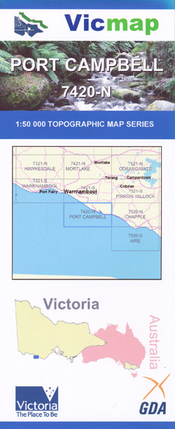
Port Campbell 1-50,000 Vicmap
Price range: $12.00 through $24.00
Description:
Port Campbell 1-50,000 scale Vicmap Topographical map 7420N is used for Walking, 4WD, Fishing, Camping, Motorcycle, both On and Off Road, Gold Prospecting and for those simply going for a family weekend drive.
Topographical maps show not only Contours of the Terrain but Walking Tracks, Sealed and Unsealed Roads, Rivers, Creeks, Lakes, Historical Points of Interest, Old Mine Sites mbtg and National and State Park areas.
Main Features of this map includes:
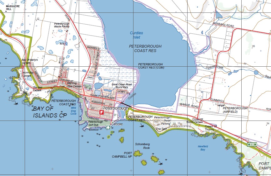
Port Campbell and Peterborough towns
Mainly Sea
Nirranda, Delaney Corner, Whiskey Creek Bridge, Curdievale, Timboon West, Fenton Creek, Port Campbell Creek, Paaratte Corner, Leech Creek, Skull Creek, Mosquito Creek, Nirranda South, Flaxman Hill, Bay of Islands CP, Heytesbury Lower, Wallaby Creek, Squirrel Creek, mbtg, Curdies Inlet, Peterborough Coast Res, Massacre Hill, Massacre Bay, Bay of Martyrs, Worm Bay, Crofts Bay, Lovers Nook, Wild Dog Cove, mbtg, Peterborough Lookout, Crown of Thomas, The Grotto, London Bridge, The Arch, Port Campbell NP, Port of Port Campbell Lookout, Sturgess Point, mbtg,
London Bridge, Two Mile Bay, Sturgess Point at Port Campbell river mouth Port Campbell Bay, Pot Campbell West Memorial, Port Campbell Rifle Range, Shelly Beach, Dog Trap Bay, Stanhope Bay, mbtg, Buttress Point, Viviennes Lookout, Flaxman Hill
ISBN 9781742085647
You may also like…
-
PORT CAMPBELL NORTH 1-25,000 Vicmap Topo 7420-1-N
Price range: $14.00 through $26.00Select options This product has multiple variants. The options may be chosen on the product page -
Warrnambool 1-50,000 Vicmap
Price range: $12.00 through $24.00Select options This product has multiple variants. The options may be chosen on the product page -
Otways West Shipwreck Coast Map Spatial Vision
Price range: $13.95 through $28.95Select options This product has multiple variants. The options may be chosen on the product page -
PORT CAMPBELL SOUTH 1-25,000 Vicmap Topo 7420-1-S
Price range: $14.00 through $26.00Select options This product has multiple variants. The options may be chosen on the product page -
Princetown Otways 1-100,000 Vicmap Topo 7520 7620
Price range: $12.00 through $24.00Select options This product has multiple variants. The options may be chosen on the product page -
Garvoc 1-50,000 Vicmap
Price range: $12.00 through $24.00Select options This product has multiple variants. The options may be chosen on the product page