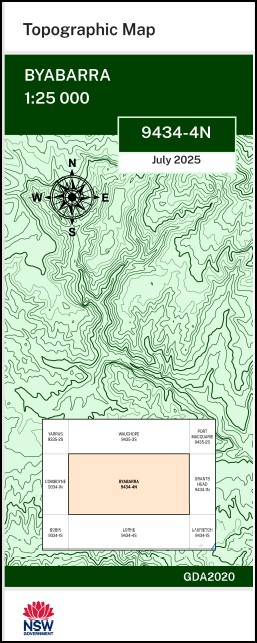
Byabarra 1-25,000 NSW Topographic Map 9434-4-N
Price range: $16.95 through $28.95
Description:
Byabarra 1-25,000 NSW Topographic Map 9434-4-N
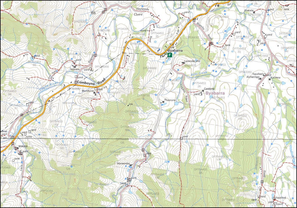
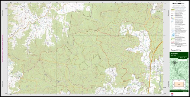
Byabarra 1-25,000 Scale NSW Topographical Map is used for Walking, 4WD, Fishing, Camping, Motorcycle, both On and Off Road, Gold Prospecting and for those simply going for a family weekend drive.
Topographical maps show not only Contours of the Terrain but also Walking Tracks, Sealed and Unsealed Roads, Rivers, Creeks, Lakes, Historical Point of Interest, Old Mine Sites and National and State Park areas.
Locations within this Map
Hillview Maryellen Alcheringa Kerewong North Glenrowan Cungeboie Glen Echo Arndale River View Bago Bluff Barneys Creek Blue Creek Black Creek Flora Reserve Black Creek Black Camp Creek Black Camp Gully Bridal Veil Falls Broken Bagho Range Broken Bago Broken Bago Range Cataract Creek Cedar Creek Cedar Scrub Creek Cold Nob Comboyne Comboyne Cemetery Mount Comboyne East Comboyne Ferny Gully Fork Creek Hartys Creek Herons Creek Herons Creek Post Office Herons Creek Public School Herons Creek Railway Station Kerewong Siding Kerewong State Forest Kew Kew State Forest Comboyne East Public School Comboyne New Ferny Creek Kerewong Range Logans Crossing Lorne Lorne State Forest North Arm North Branch State Forest Queens Lake River Ralfe Rock Nob Rollover Signal Hill Smiths Creek South Arm The Rollover The Roll Over Mount Tirrandubundeba Tirrandubundeba Upsalls Creek State Forest Upsel State Forest Walibree Walkers Creek Waterfall Creek Bulli Creek Bulls Ground State Forest Ducks Knob Byabarra Byabarra Public School Blue Creek Dam Lorne Flora Reserve Mitchells Falls Swans Crossing Bago Quintoc Hills Broken Bargo Range Kerewang Siding Kerewong Upsalls Creek
| Name: | Byabarra |
| Publisher: | New South Wales Government |
| Scale: | 1:25,000 |
| Latitude Range: | 31° 30.0′ S – 31° 37.5′ S |
| Longitude Range: | 152° 30.0′ E – 152° 45.0′ E |
| Datum: | GDA 2020 |
| Approx Print Size: | 0.56m X 1.11m |
| Publication Date: | 2025 |
You may also like…
-
Laurieton 1-25,000 NSW Topographic Map 9434-1-S
Price range: $16.95 through $28.95Select options This product has multiple variants. The options may be chosen on the product page -
Grants Head 1-25,000 NSW Topographic Map 9434-1-N
Price range: $16.95 through $28.95Select options This product has multiple variants. The options may be chosen on the product page -
Lorne 1-25,000 NSW Topographic Map 9434-4-S
Price range: $16.95 through $28.95Select options This product has multiple variants. The options may be chosen on the product page