

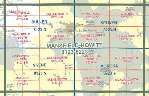
HOWITT SOUTH 1-25,000 Vicmap Topo Map 8223-4-S
Price range: $14.00 through $26.00
Description:
HOWITT SOUTH 1-25,000 Vicmap Topographic Map 82234S Now Print On Demand is used for Walking, 4WD, Fishing, Camping, Motorcycle, both On and Off Road, Gold Prospecting and for those simply going for a family weekend drive.
This is a new series of 1-25,000 scale maps, all of Victoria is now covered by these maps, including maps over the South Australian and NSW Borders.
Topographical maps show not only Contours of the Terrain but Walking Tracks, Sealed and Unsealed Roads, Rivers, Creeks, Lakes, Historical Points of Interest, Old Mine Sites mbtg and National and State Park areas.
Also now available printed on Plastic Waterproof Paper Folded
Main Features of this map includes:
Part of the Alpine Walking Track
Mount Howitt, Mount Stirling, Grassy Saddle, Third Spur, Third Mile Spur, MOUNT EADLEY STONEY, Rocky Knob, Bluff Hut Camping Area, Waterhole Saddle, Lovicks Hut Camping Area, Picture Point, Helicopter Spur, Upper Howqua Camping Area, Red Rock Saddle, Mount Thorn, The Pimple, MOUNT MAGDALA, MOUNT MARJORIE, Hells Window, mbtg, King Billy 1, King Billy 2, Macalister Area Remote and Natural Area, The crags, THE CROSSCUT SAW, West Peak, Macalister Springs Camping Area, D E V I L S S TA I R C A S E, MOUNT BUGGERY, MOUNT SPECULATION, Howitt Trail Head And Camping Area, Howitt Plains, Howitt Hut And Camping Area, Part of the Bicentenial Track at Howitt Hut, BARSTARDS NECK, Mount Darling – Snowy Bluff Wilderness Zone, WONNANGATTA SPUR
You may also like…
-
Selwyn 1-50,000 Vicmap
Price range: $12.00 through $24.00Select options This product has multiple variants. The options may be chosen on the product page -
Buller 1-50,000 Vicmap
Price range: $12.00 through $24.00Select options This product has multiple variants. The options may be chosen on the product page -
HOWITT NORTH 1-25,000 Vicmap Topo Map 8223-4-N
Price range: $14.00 through $26.00Select options This product has multiple variants. The options may be chosen on the product page -
Jamieson Licola Adventure Map Rooftop
Price range: $11.95 through $25.00Select options This product has multiple variants. The options may be chosen on the product page -
Mansfield Mt Howitt Map Rooftop
Price range: $8.95 through $17.00Select options This product has multiple variants. The options may be chosen on the product page -
BULLER SOUTH 1-25,000 Vicmap Topo Map 8123-1-S
Price range: $14.00 through $26.00Select options This product has multiple variants. The options may be chosen on the product page -
Buller North 1-25,000 Vicmap Topographic Map 8123-1-N
Price range: $14.00 through $26.00Select options This product has multiple variants. The options may be chosen on the product page