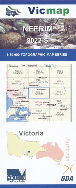
Neerim 1-50,000 Vicmap
Price range: $12.00 through $26.00
Description:
Neerim 1-50,000 scale Vicmap Topographical map 8022S is used for Walking, 4WD, Fishing, Camping, Motorcycle, both On and Off Road, Gold Prospecting and for those simply going for a family weekend drive.
Topographical maps show not only Contours of the Terrain but Walking Tracks, Sealed and Unsealed Roads, Rivers, Creeks, Lakes, Historical Points of Interest, Old Mine Sites mbtg and National and State Park areas.
Main Features of this map includes:
Launching Place, Yarra Junction, Warburton, Hoddles Creek, Yellingbo, Beenak, Top of Kirth Kiln, Gladysdale, Big Pats Creek, Britannia Creek Cave, Part of the Yarra State Park, Wesburn, Millgrove, Killara, mbtg, Woori Yallock, SHEEP STATION CREEK NCA, Nangana, LUSATIA PARK ROAD BR, LONE STAR CREEK BR, HODDLES CREEK BR, Don Valley, Millgrove Outdoor Educationa Centre – Melbourne High, Mount Thule, Milner Hill, Three Bridges, BRITTANIA CREEK CAVE GR, Mount Little Joe, Old Warburton, MOUNT TUGWELL, Gilderoy, MOUNT MYRTALIA, Ezard Spur, MOUNT BRIDE, mbtg, Gembrook Mount Beenak, Part of Bunyip State Park, The Ship Rock, Gilwell Park, Bottom of Kirth Kiln, Cockatoo, Puffing Billy Historic Area, mbtg, MOUNT BURNETT, MOUNT EIRENE, Mortimer Camping And Picnic Area, Whites Corner, Tims Corner, Diamond Creek Reference Area (no public access), Tomohawk Gap, Basan Corner, Bunyip Weir (Freemans Mill) Camping Area, Seven Acre Cascades, SEVEN ACRE ROCK NFSR
You may also like…
-
McMahons Creek 1-50,000 Vicmap
Price range: $12.00 through $26.00Select options This product has multiple variants. The options may be chosen on the product page -
Glenburn 1-50,000 Vicmap
Price range: $12.00 through $24.00Select options This product has multiple variants. The options may be chosen on the product page -
Monbulk 1-50,000 Vicmap
Price range: $12.00 through $24.00Select options This product has multiple variants. The options may be chosen on the product page -
Neerim 1-50,000 Vicmap
Price range: $12.00 through $26.00Select options This product has multiple variants. The options may be chosen on the product page -
Walhalla 1-50,000 Vicmap Topo Map 8122-S
Price range: $12.00 through $24.00Select options This product has multiple variants. The options may be chosen on the product page -
Moe 1-50,000 Vicmap
Price range: $12.00 through $24.00Select options This product has multiple variants. The options may be chosen on the product page -
Warburton Trail 1-25,000 Scale Topographic Maps Vicmap
Price range: $24.00 through $48.00Select options This product has multiple variants. The options may be chosen on the product page -
NEERIM NORTH 1-25,000 Vicmap Topo Map 8022-2-N
Price range: $14.00 through $26.00Select options This product has multiple variants. The options may be chosen on the product page -
Gembrook South 1-25,000 Vicmap Topographic Map
Price range: $14.00 through $26.00Select options This product has multiple variants. The options may be chosen on the product page -
Gembrook North 1-25,000 Vicmap Topographic Map
Price range: $12.00 through $26.00Select options This product has multiple variants. The options may be chosen on the product page -
Aberfeldy 1-50,000 Vicmap
Price range: $12.00 through $24.00Select options This product has multiple variants. The options may be chosen on the product page -
NEERIM SOUTH 1-25,000 Vicmap Topo Map 8022-2-S
Price range: $14.00 through $26.00Select options This product has multiple variants. The options may be chosen on the product page