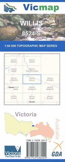
Willis 1-50,000 Vicmap
Price range: $12.00 through $24.00
Description:
Willis 1-50,000 scale Vicmap Topographical map 8524S is used for Walking, 4WD, Fishing, Camping, Motorcycle, both On and Off Road, Gold Prospecting and for those simply going for a family weekend drive.
Topographical maps show not only Contours of the Terrain but Walking Tracks, Sealed and Unsealed Roads, Rivers, Creeks, Lakes, Historical Points of Interest, Old Mine Sites mbtg and National and State Park areas.
Main Features of this map includes:
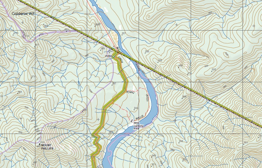
The beginning of the Murray River, Suggan Buggan, Snowy River across the Victoria NSW Border, Round Mountain, Mount Cobberas and the Cobbers Wilderness Zone, Beehive Creek, mbtg, Macfarlane Flat Hut, Macfarlane Flat, Cobberas Wilderness Zone, Suggan Buggan Remote and Natural Area. Omeo Flat, Snowgum Flat, Ingeegoodbee River, Moyangul Historic Area, MOUNT TROOPER, Pinch Mountain, Jacobs River Picnic And Camping Area, Suggan Buggan, Suggan Buggan River, mbtg, Mount STRADBROKE, Mount STRADBROKE Walking Track, Gelantipy State Forest, Little Mount Hamilton, Ballantyne Gap and Hills, Mount MENAAK, Monaro Gap, Hughes Gap, BARRABILLI MOUNTAIN, Mountain Hut Peak, Mount Phillips, Willis Hut Area, Upper Snowy Area Remote and Natural Area, Beehive Creek Reference Area (no public access), Beehive Creek Reference Area (no public access), Gattamurh Creek Natural Catchment Area, Mount Taylor, Amboyne State Forest
Cobberas Wilderness Zone, MOUNT COBBERAS NUMBER ONE, MOUNT COBBERAS NUMBER TWO, DOCKERTY Point, The Ladde, Benambra State Forest, Smoko Creek Track, mbtg, Limestone Creek Camping Area, Davies Plain Remote and Natural Area, Wilderness Zone, Round Mountain, The Poplars Camping Area, Suggan Buggan Remote and Natural Area, Moscow Peak, Cleft Peak, Middle Peak, C o w o m b a t F l a t, The Pilot, Forest Hill Reference Area (no public access), Suggan Buggan Remote and Natural Area,
Part of the Bicentenial Trail
Limestone Track, RODS DOWNFALL, Cobberas Wilderness Zone, COWOMBAT Flat Track, Native Dog Flat, Buchan River, Buchan Headwaters Wilderness Zone, Rams Horn, Forlorn Hope Track, MOUNT WOMBARGO, Buchan Tops, Gelantipy State Forest, Mount Stradbroke Walking Track
ISBN 9781742086224
You may also like…
-
Leinster 1-50,000 Vicmap
Price range: $12.00 through $24.00Select options This product has multiple variants. The options may be chosen on the product page -
Deddick 1-50,000 Vicmap
Price range: $12.00 through $24.00Select options This product has multiple variants. The options may be chosen on the product page -
Tom Groggin 1-50,000 Vicmap Topographic Map 8524-N
Price range: $14.00 through $26.00Select options This product has multiple variants. The options may be chosen on the product page -
Bindi 1-50,000 Vicmap
Price range: $12.00 through $24.00Select options This product has multiple variants. The options may be chosen on the product page -
Byadbo 1-50,000 Vicmap
Price range: $12.00 through $24.00Select options This product has multiple variants. The options may be chosen on the product page -
Bendoc 1-50,000 Vicmap
Price range: $12.00 through $24.00Select options This product has multiple variants. The options may be chosen on the product page -
Suggan Buggan 1-50,000 NSW Topographic Map 8524-S
Price range: $16.95 through $29.95Select options This product has multiple variants. The options may be chosen on the product page -
Gibbo 1-50,000 Vicmap
Price range: $12.00 through $24.00Select options This product has multiple variants. The options may be chosen on the product page