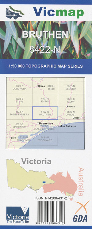
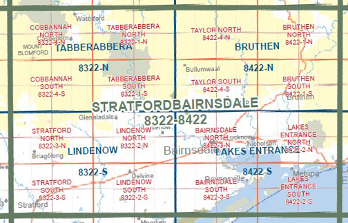
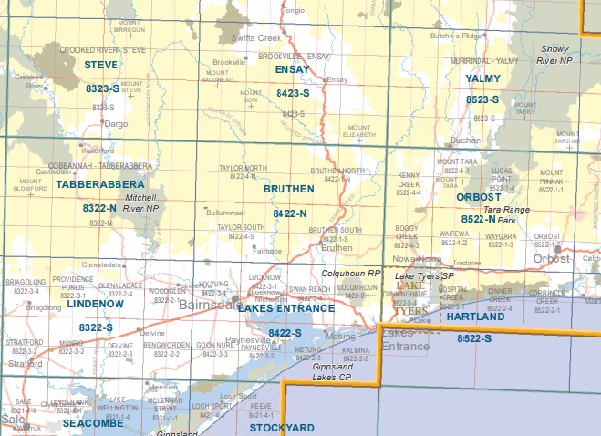
Bruthen 1-50,000 Vicmap
Price range: $12.00 through $24.00
Description:
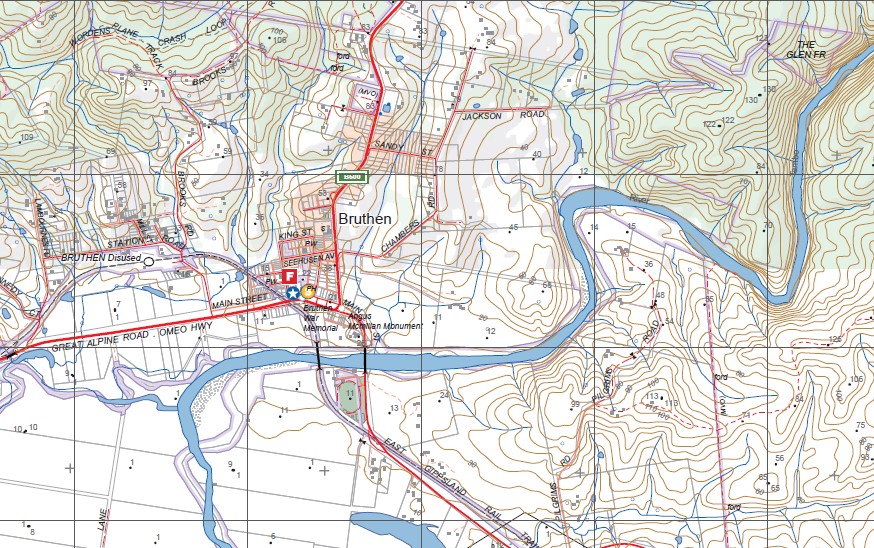
Bruthen 1-50,000 scale Vicmap Topographical map 8422n is used for Walking, 4WD, Fishing, Camping, Motorcycle, both On and Off Road, Gold Prospecting and for those simply going for a family weekend drive.
Topographical maps show not only Contours of the Terrain but Walking Tracks, Sealed and Unsealed Roads, Rivers, Creeks, Lakes, Historical Point of Interest, Old Mine Sites mbtg and National and State Park areas.
Main Features of this map includes:
Bruthen, Tambo Crossing, Tambo River, Haunted Stream State Forest, Lanky Tom Spur, Yowen Burrun State Forest, Buchan State Forest, Barksheds Creek, Bruthen State Forest, Gurrun Gurrun Yarn State Forest, Double Bridges, Fainting Range State Forest, MOUNT ELIZABETH NCR, Tambo River Reference Area (no public access), Timbarra River, Kenny State Forest, Yowen Burrun State Forest, FAIRY DELL FR, SARSFIELD BR, MOSSIFACE BR, Angus Mcmillan Monument, mbtg, Tambo BR, WISELEIGH BR, Bruthen State Forest, MOUNT LITTLE DICK, East Gippsland Rail Trail, Greg Ridsdale Memorial Camp Park, mbtg, KILMORIE Hill, Ramrod Creek, Colquhoun Boyanga Gidi State Forest, Gurrun Gurrun Yarn State Forest, Kenny State Forest, Radar Hill
Nicholson River, Deptford, THE WOOLY BUTT SPUR, Cool Waters Quarry, Warriballat State Forest, Argus Gap, Mount Hoad, STUTTERIN FRED, mbtg, Bullung Warl State Forest, Mount Welcome, Haunted Stream State Forest, Browns Peak and Saddle, Bullumwaal, Warriballat State Forest, Mount Alfred, Mount Alfred State Forest, mbtg, MELWOOD EA, Mount Taylor, Bullung Warl State Forest, Clifton Creek, Fairhope, MCARTHUR POINT, Nicholson River, Honey Bird Bridge, Yowen Burrun State Forest, GENTLE ANNIE HILL, Wards Crossing, GEBHARDTS Old Man Link Track
ISBN 9781742084312
You may also like…
-
LAKES ENTRANCE NORTH 1-25,000 Vicmap 8422-2-N
Price range: $14.00 through $26.00Select options This product has multiple variants. The options may be chosen on the product page -
Tabberabbera 1-50,000 Vicmap
Price range: $12.00 through $24.00Select options This product has multiple variants. The options may be chosen on the product page -
BAIRNSDALE SOUTH 1-25,000 Vicmap Map 8422-3-S
Price range: $14.00 through $26.00Select options This product has multiple variants. The options may be chosen on the product page -
STEVE NORTH 1-25,000 Vicmap Topo Map 8323-2-N
Price range: $14.00 through $26.00Select options This product has multiple variants. The options may be chosen on the product page -
Orbost 1-50,000 Vicmap Topographical Map 8522-N
Price range: $14.00 through $26.00Select options This product has multiple variants. The options may be chosen on the product page -
Hartland 1-50,000 Vicmap
Price range: $12.00 through $24.00Select options This product has multiple variants. The options may be chosen on the product page -
BAIRNSDALE NORTH 1-25,000 Vicmap Map 8422-3-N
Price range: $14.00 through $26.00Select options This product has multiple variants. The options may be chosen on the product page -
CROOKED RIVER NORTH 1-25,000 Vicmap Map 8323-3-N
Price range: $14.00 through $26.00Select options This product has multiple variants. The options may be chosen on the product page -
STEVE SOUTH 1-25,000 Vicmap Topo Map 8323-2-S
Price range: $14.00 through $26.00Select options This product has multiple variants. The options may be chosen on the product page -
Ensay 1-50,000 Vicmap
Price range: $12.00 through $24.00Select options This product has multiple variants. The options may be chosen on the product page -
CROOKED RIVER SOUTH 1-25,000 Vicmap Map 8323-3-S
Price range: $14.00 through $26.00Select options This product has multiple variants. The options may be chosen on the product page -
Lakes Entrance 1-50,000 Vicmap
Price range: $12.00 through $24.00Select options This product has multiple variants. The options may be chosen on the product page -
Lindenow 1-50,000 Vicmap
Price range: $12.00 through $24.00Select options This product has multiple variants. The options may be chosen on the product page -
LAKES ENTRANCE SOUTH 1-25,000 Vicmap 8422-2-S
Price range: $14.00 through $26.00Select options This product has multiple variants. The options may be chosen on the product page -
Bairnsdale Dargo Omeo Adventure Map Rooftop
Price range: $12.95 through $25.00Select options This product has multiple variants. The options may be chosen on the product page