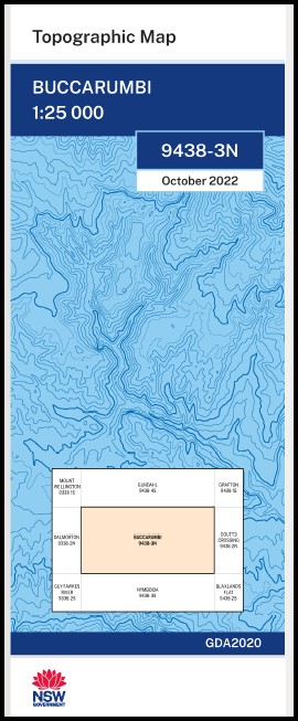
Buccarumbi 1-25,000 NSW Topographic Map 9438-3-N
Price range: $16.95 through $28.95
Description:
Buccarumbi 1-25,000 NSW Topographic Map 9438-3-N
Now Print on Demand
Locations within this Map
Chillumbarriga River View Rowena Rockview Adams Crossing Big Creek Blackhole Creek Blackhole Bloxoms Creek Boyd Boyd River Buccarumbi Buccarumbi Creek Buccarumbi Range Cedar Gully Chambigne Chambigne Creek Deep Gully Endless Creek Ermington Flying Fox Creek Glens Creek Glens Crossing Gulph Creek Cedar Creek Craggy Creek Gulf Creek Little River Louis Point Nymboi Nymboida State Forest Obx Creek Ross Creek Sheep Station Creek Sideling Creek Sideling Gully Southern Branch / Doboy Creek Stave Creek Stinking Creek Stouts Creek Thorntons Creek Thorolds Creek Dights Creek Dingo Creek Bullock Creek Doboy Creek Double Jump Creek Dry Creek O.B.X. Creek
| Scale: | 1:25,000 |
| Latitude Range: | 29° 45.0′ S – 29° 52.5′ S |
| Longitude Range: | 152° 30.0′ E – 152° 45.0′ E |
| Datum: | GDA 2020
Edition 2022 |
| Approx Print Size: | 0.56m X 1.11m |
You may also like…
-
Grafton 1-25,000 NSW Topographic Map 9438-1-S
Price range: $16.95 through $28.95Select options This product has multiple variants. The options may be chosen on the product page -
Nymboida 1-25,000 NSW Topographic Map
Price range: $16.95 through $31.95Select options This product has multiple variants. The options may be chosen on the product page -
Blaxlands Flat 1-25,000 NSW Topographic Map
Price range: $16.95 through $31.95Select options This product has multiple variants. The options may be chosen on the product page -
Gundahl 1-25,000 NSW Topographic Map 9438-4-S
Price range: $16.95 through $28.95Select options This product has multiple variants. The options may be chosen on the product page